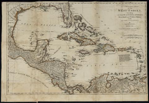
Compleat Map of the West Indies : Containing the Coasts...
Section: Maps, plans and nautical charts
Uniform title: AMERICA CENTRAL. Mapas generales. 1776. 1:9000000 (1774)
Title: Compleat Map of the West Indies : Containing the Coasts of Florida, Louisiana, New Spain and Terra Firma with all the Islands / by Samuel Dunn, Mathematician
Material or type of resouce Area: Escala [ca. 1:9000000] ; [Proyec. cónica directa equidistante], 100 Sea Leagues 20 in a Degree [= 6'3 cm]
Publication: London : Printed for Robt. Sayer, Nº 53 in Fleet Street, as the Act directs, 10 Janvary [1776]
Physical description: 1 mapa : col. ; 31 x 45 cm, pleg. 20 x 10 cm
Notes: Comprende el Golfo de México, América Central, el mar Caribe y la costa norte de América del Sur
En: "The American Military Pocket Atlas...". nº. 2
Escala gráfica de 300 millas inglesas de 69 1/2 al grado [= 5'4 cm]. Coordenadas referidas al meridiano de Hierro (E 83º30'-E 40º00'/N 30º00'-N 06°50'). Red geográfica de 10º en 10º
Relieve de perfil
Indica veriles y bajos
Nota relacionada con las Pequeñas Antillas y sus diferencias
Señala los límites entre las colonias cromáticamente
Materia / lugar / evento: Mapas generales
Colonias
Golfos
Islas
Fronteras
1774
México
Caribe (Mar)
América Central
Other authors: Dunn, Samuel, m. 1794
Sayer, Robert, 1725-1794
Related titles: Título: The American Military Pocket Atlas
UDC: (728)
Type of publication:
![]() Maps
Maps


