Süd-Afrika & Madagaskar in maassstabe von 1:12.5000.000


 Maps, plans and nautical charts
Süd-Afrika & Madagaskar in maassstabe von 1:12.5000.000 (1879)
- Petermann, Augustus, 1822-1878
Maps, plans and nautical charts
Süd-Afrika & Madagaskar in maassstabe von 1:12.5000.000 (1879)
- Petermann, Augustus, 1822-1878
 Disponible Holdings
 Section: Maps, plans and nautical charts
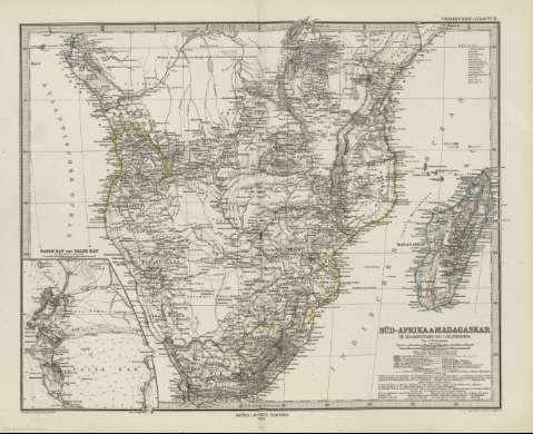
Title: Süd-Afrika & Madagaskar in maassstabe von 1:12.5000.000 / von A. Petermann ; gezeichnet v. H. Habemicht ; Gest v. C. Stier , Terraiin v. C. Jungmann
Author: Petermann, Augustus, 1822-1878
Material or type of resouce Area: 1:12.500.000 (E 5 -E 54 /N 2 -S 35)
Publication: Gotha [Alemania] : Justus Perthes, 1879
Physical description: 1 mapa : col. ; 33 x 41 cm, en h. de 39 x 48 cm, pleg. en 39 x 24 cm
Content type: Imagen cartográfica
Media type: computadora
Carrier type: recurso en línea
Notes: Coordenadas según el meridiano de París e Hierro
Relieve representado por normales
Leyenda de signos utilizados
Inserta: Table Bay und False Bay.- im Maasftab 1:500.000
En el margen superior derecho : "Stieler's Hand-Atlas Nº 71"
Copia digital . España : Ministerio de Cultura y Deporte. Subdirección General de Coordinación Bibliotecaria, 2010
Other titles: En: Hand atlas : über alle Theile der Erde und über das Weltgebäude. - Gotha [Alemania R.D.] : Justus Perthes, [1879]. - N. 71
Materia / lugar / evento: Mapas generales
Madagascar
Sudáfrica
Other authors: Stieler, Adolf, 1775-1836
Habenicht, Hermann, 1844-1917
Stier, Carl, -1875
Jungmann, Carl
Justus Perthes (Firma)
Related titles: AFRICA. S. Mapas generales. 1879. 1:12500000 (18)
UDC: 912:[341.222:341.222](6-13+691)'1806/1872'
6-13
691
Type of publication:
Maps
Rights:
