Spanien und Portugal in 4 blättern : [generalkarte]


 Maps, plans and nautical charts
Spanien und Portugal in 4 blättern : [generalkarte] (1879)
- Vogel, C
Maps, plans and nautical charts
Spanien und Portugal in 4 blättern : [generalkarte] (1879)
- Vogel, C
 Disponible Holdings
 Section: Maps, plans and nautical charts
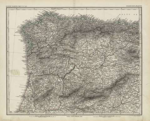
Title: Spanien und Portugal in 4 blättern : [generalkarte] / Von C. Vogel ; schrift von H. Eberhardt & E. Kuhn
Material or type of resouce Area: Escala 1:1.500.000
Publication: Gotha [Alemania] : Justus Perthes, 1879
Physical description: 1 mapa en 4 h. : col. ; h. de 39x48 cm, pleg. en 39x24 cm
Content type: Imagen cartográfica
Media type: computadora
Carrier type: recurso en línea
Notes: Coordenadas : O9 35'-O18 00'/N43 47'-N36 00'. Meridiano de Ferro. Constan ademas coordenadas según el meridiano de París
Relieve : líneas perpendiculares normales
Leyenda de signos utilizados
Inserta : Plano población de Madrid. - Escala 1:150000
Texto explicativo del contenido del mapa
En el margen superior derecho de cada una de las hojas: "Stieler's Hand-Atlas Nº 39 al 42"
Copia digital . España : Ministerio de Cultura y Deporte. Subdirección General de Coordinación Bibliotecaria, 2010
Other titles: En: Hand atlas : über alle Theile der Erde und über das Weltgebäude. - Gotha [Alemania R.D.] : Justus Perthes, [1879]. - N 39-42
Other authors: Eberhardt, Hermann, 1811-1885
Stieler, Adolf, 1775-1836
Kühn. E., fl. 1879
Justus Perthes (Firma)
Related titles: España. Mapas generales. 1:1500000 (1879)
UDC: 912:341.222(460+469)'1879'
460
469
912:314(44 Madrid)(084.3) '1879'
Type of publication:
Maps
Rights:
