Das Capland nebst dem Cebiet der Hottentotten und Kaffern...


 Maps, plans and nautical charts
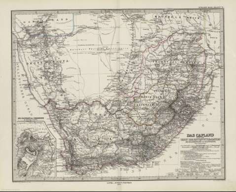
Das Capland nebst dem Cebiet der Hottentotten und Kaffern im Maassstabe von 1:5.000.000 : [generalkarte] (1879)
- Petermann, Augustus, 1822-1878
Maps, plans and nautical charts
Das Capland nebst dem Cebiet der Hottentotten und Kaffern im Maassstabe von 1:5.000.000 : [generalkarte] (1879)
- Petermann, Augustus, 1822-1878
 Disponible Holdings
 Section: Maps, plans and nautical charts
Title: Das Capland nebst dem Cebiet der Hottentotten und Kaffern im Maassstabe von 1:5.000.000 : [generalkarte] / Von A. Petermann ; Bearbeitet von Habenich ; Gest. v. Poppey u. Jungmam
Author: Petermann, Augustus, 1822-1878
Material or type of resouce Area: Escala 1:5000000
Publication: Gotha [Alemania] : Justus Perthes, 1879
Physical description: 1 mapa : col. ; 33x41 cm, en h. de 39x48 cm, pleg. en 39x24 cm
Content type: Imagen cartográfica
Media type: computadora
Carrier type: recurso en línea
Notes: Constan ademas coordenadas según el meridiano de París y Ferro
Relieve : líneas perpendiculares normales
Leyenda de signos utilizados
Inserta : Die Capstadt und Umgebung im Maassstad 1:150000
En el margen superior derecho : "Stieler's Hand-Atlas Nº 72"
Copia digital . España : Ministerio de Cultura y Deporte. Subdirección General de Coordinación Bibliotecaria, 2010
Other titles: En: Hand atlas : über alle Theile der Erde und über das Weltgebäude. - Gotha [Alemania R.D.] : Justus Perthes, [1879]. - N 72
Materia / lugar / evento: Mapas generales
Sudáfrica
Namibia
Mozambique
Other authors: Stieler, Adolf, 1775-1836
Habenicht, Hermann, 1844-1917
Jungmann, Carl
Poppey, Carl, 1829-1875
Justus Perthes (Firma)
Related titles: SUDAFRICA. 1:5000000
UDC: 912:341.222(680+688+679)'1812/1872'
680
688
679
Type of publication:
Maps
Rights:
