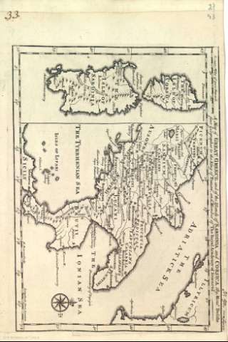
A Map of Great Greece and of the Islands of Sardinia and...


 Maps, plans and nautical charts
A Map of Great Greece and of the Islands of Sardinia and Corsica
- Delisle, Guillaume, 1675-1726
Maps, plans and nautical charts
A Map of Great Greece and of the Islands of Sardinia and Corsica
- Delisle, Guillaume, 1675-1726
Section: Maps, plans and nautical charts
Title: A Map of Great Greece and of the Islands of Sardinia and Corsica / By Delisle first Geographer to the King od France...
Author: Delisle, Guillaume, 1675-1726
Material or type of resouce Area: Escala [ca.1:3.086.420]
Physical description: 1 mapa ; 32 x 22 cm
Content type: Imagen cartográfica
Media type: computadora
Carrier type: recurso en línea
Notes: Orientado con lis en rosa de ocho vientos inscrita en círculo
Márgenes graduados
Relieve por montes perfil y sombreado
Costas sombreadas con un fino rayado
Red hidrográfica
Ciudades representadas por pequeños conjuntos de edificaciones
Limites de las divisiones administrativas
Toponimia de las regiones, algunos nombres de ciudades, montañas, lagos y ríos
Copia digital. Madrid : Ministerio de Cultura, 2010
Inserta: "The isle of Sardinia" y "The isle of Corsica"
Other titles: En: [The maps and plans of the Universal History]. - [Lugar de publicación no identificado] : [Editor no identificado], [1700-1812?]. - [Mapa 23]
Materia / lugar / evento: Mapas históricos
Geografía histórica
Civilizaciones antiguas
Mapas generales
Islas
Historia
Edad Antigua
Italia
Córcega
Cerdeña
UDC: (450)
(44 Corcega)
Type of publication:
Maps
