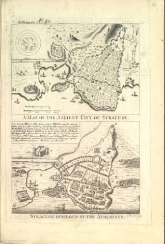
A Map of the Ancient City of Syracuse ; Syracuse...


 Maps, plans and nautical charts
A Map of the Ancient City of Syracuse ; Syracuse Besieged by the Athenians
Maps, plans and nautical charts
A Map of the Ancient City of Syracuse ; Syracuse Besieged by the Athenians
Section: Maps, plans and nautical charts
Uniform title: Siracusa. Ciudades Planos. 1700-1812
Title: A Map of the Ancient City of Syracuse ; Syracuse Besieged by the Athenians / I. Blundell sculp
Material or type of resouce Area: Escala sin determinar
Physical description: 1 plano ; 32 x 20 cm
Content type: Imagen cartográfica
Media type: computadora
Carrier type: recurso en línea
Notes: Clave alfabética para indicar los edificios y lugares más significativos
Edificios y fortalezas de perfil
Árboles representados
Relieve por sombreado
Hidrografía
Decorados con barcos de época
Representación de soldados
Copia digital. Madrid : Ministerio de Cultura, 2010
Other titles: En: [The maps and plans of the Universal History]. - [Lugar de publicación no identificado] : [Editor no identificado], [1700-1812?]. - [Mapa 15]
Materia / lugar / evento: Planos de población
Ciudades antiguas
Islas
Geografía histórica
Fortificaciones
Historia
Edad Antigua
Sicilia
Siracusa
Italia
Other authors: Blundell, J.
Related titles: Título: Syracuse Besieged by the Athenians
UDC: 45 Sicilia
Type of publication:
Maps
