Campaign Maps accompanying report of But. Maj. Gen. J.W....


 Maps, plans and nautical charts
Campaign Maps accompanying report of But. Maj. Gen. J.W. Geary, U.S. Army, for the campaign from Savannah, Ga.,... (189-?)
Maps, plans and nautical charts
Campaign Maps accompanying report of But. Maj. Gen. J.W. Geary, U.S. Army, for the campaign from Savannah, Ga.,... (189-?)
 Disponible Holdings
 Section: Maps, plans and nautical charts
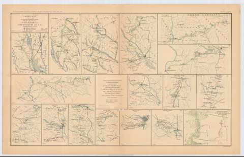
Title: Campaign Maps accompanying report of But. Maj. Gen. J.W. Geary, U.S. Army, for the campaign from Savannah, Ga., Goldsborough, N.C., 2d. Division, 20th. Corps : title to maps 1 to 7 inclusive / Top. Engr. Office, 2d. Div. 20th Corps
Material or type of resouce Area: Escala [ca. 1:506876], 8 Miles to the inch
Publication: Washington : Government Printing Office, [189-?] (N.Y. [Nueva York] : Julius Bien & co.)
Physical description: 6 mapas en 1 h. : col. ; 20x27 cm ó menos en h. de 47x75 cm
Content type: Imagen cartográfica
Media type: computadora
Carrier type: recurso en línea
Notes: En : Atlas to accompany the Official Records of the Union and Confederate Armies 1861-1865. - Plate LXXXVI, n 1-7
Figura : 'Series I. Vol. XLVII
Leyenda de símbolos
En : Atlas to accompany the Official Records of the Union and Confederate Armies 1861-1865
Materia / lugar / evento: Guerra civil
Maniobras de campaña
Estrategia militar
Planos de población
Redes de transporte
S.XIX
Carolina del Sur
Georgia (Estados Unidos)
Carolina del Norte
Estados Unidos
Other authors: Estados Unidos. Topographical Engineer Office
UDC: 912:355.4]:[355.52+355.43](757+758)'1865'
912:314(757+758+756)(084.3)
(757)
758
756
Type of publication:
Maps
Rights:
Préstamo:
Disponible
