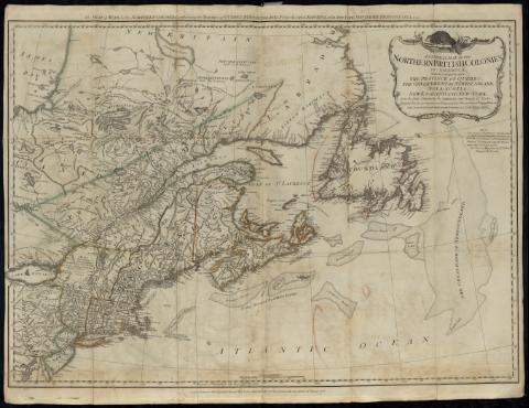
General Map of the Northern British Colonies in America :...
Section: Maps, plans and nautical charts
Uniform title: AMERICA DEL NORTE. NE. Mapas generales. 1:4000000 (1776)
Title: General Map of the Northern British Colonies in America : which comprehends the Province of Quebec, the Government of Newfoundland, Nova-Scotia, New-England and New York : from the Maps Published by the Admiralty and Board of Trade, Regulated by the Astronomic and Trigonometric Observations of Major Holland / and Corrected from Governor Pownall's Late Map 1776
Material or type of resouce Area: [Ca. 1:4000000] ; 200 British Statute Miles [= 8,4 cm]
Publication: London : Printed for Robt. Sayer & Jh° Bennett, Map & Sea Chartseller, N° 53, Fleet Streets, as the Act directs, 14 Th. August 1776
Physical description: 1 mapa : col. ; 48 x 66 cm, pleg. en 23 x 12 cm
Notes: En: The American Military Pocket Atlas... [Mapa] 3
Coordenadas referidas al meridiano de Londres (E 82°00'-E 44°10'/N 54°10'-N 38°40'. Red geográfica de 5° en 5°
Relieve de perfil
Indica bancos de arena
Nota referente a la dependencia administrativa de las islas del Golfo de San Lorenzo
En el margen superior: "The Seat of War, in the Northern Colonies, containing the Province of Quebec, New-Foundlan, Nova-Scotia, New-England, New-York, New-Jersey, Pennsylvania & ca."
Señala los límites entre las distintas divisiones administrativas de las colonias inglesas cromáticamente
Título enmarcado en cartela decorada con motivos vegetales
Materia / lugar / evento: Mapas generales
Divisiones administrativas
Colonias
1776
Canadá
Estados Unidos
América del Norte
Other authors: Robert Sayer and John Bennett (Firma)
Related titles: Título: The American Military Pocket Atlas
UDC: 7-18
Type of publication:
![]() Maps
Maps


