Projet D'Agrandissement Général Modifié et divers autres...


 Maps, plans and nautical charts
Projet D'Agrandissement Général Modifié et divers autres projets (1858)
- Keller et Compie.
Maps, plans and nautical charts
Projet D'Agrandissement Général Modifié et divers autres projets (1858)
- Keller et Compie.
 Disponible Holdings
 Section: Maps, plans and nautical charts
Title: Projet D'Agrandissement Général Modifié et divers autres projets / Keller &Cie.
Author: Keller et Compie.
Material or type of resouce Area: [Ca. 1:10.000]
Publication: [París : Ch. Tanera Éditeur Librairie pour L'Art Militaire, les Sciences et les Arts. Quai des Augustins, 27, 1858]
Physical description: 1 mapa : col. ; 87 x 116 cm, pleg. en 44 x 30 cm
Content type: Imagen cartográfica
Media type: computadora
Carrier type: recurso en línea
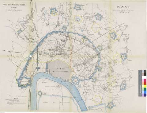
Notes: En el margen derecho : "Plan Nº 1 Annexe à notre lettre du 5 Octobre 1858 (signe) Keller & Cie."
Orientado con flecha con el N. al O. de la hoja
Incluye leyenda que marca, por colores, los proyectos y reformas de la ciudad
Fortalezas representadas mediante polígono pentagonal
Copia digital . España : Ministerio de Cultura y Deporte. Subdirección General de Coordinación Bibliotecaria, 2010
Other authors: Charles Tanera (Imprenta)
Related titles: AMBERES (Bélgica). Planos de población ([1858]). Ca. 1:10.000
UDC: 912:314(493 Amberes)(084.3)'1885'
912:623.1]:[626.1:625.1:625:711.4] (493 Amberes)'1885'(083.9)
493 Amberes
Type of publication:
Maps
Rights:
