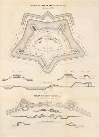
Project de Fort en Terre (pour mémoire) [plan]


 Disponible Holdings
 Section: Maps, plans and nautical charts
Uniform title: AMBERES (Bélgica). Fortificaciones. [1858]
Title: Project de Fort en Terre (pour mémoire) [plan]
Material or type of resouce Area: Escala indeterminada
Publication: [París] : [Ch. Tanera Éditeur. Librairie pour L'Art Militaire, les Sciences et les Arts. Quai des Augustins, 27], [1858]
Physical description: 1 plano ; 60 x 44 cm, pleg. en 43 x 30 cm
Content type: Imagen cartográfica
Media type: computadora
Carrier type: recurso en línea
Notes: Bajo el título consta: "Voir annexe Nº 15"
Presenta 4 cortes: sur CD, EF, GH, AB. Escala 1:2.000 = Projet D'Enceinte Polygonale, en horizont bas et en horizont élevé. Escala 1:5.000
Materia / lugar / evento: Fortificaciones
Amberes
Other authors: Charles Tanera (Imprenta)
UDC: 912:725.94:(493 Amberes)'1858'
493
Type of publication:
 Maps
Maps
Rights:
