Welt - Karte : Zur Ubersicht der Meeres - Strömungen und...


 Maps, plans and nautical charts
Welt - Karte : Zur Ubersicht der Meeres - Strömungen und des Schnellverkehrs : [Karte] (1879)
- Berghaus, Hermann, 1828-1890
Maps, plans and nautical charts
Welt - Karte : Zur Ubersicht der Meeres - Strömungen und des Schnellverkehrs : [Karte] (1879)
- Berghaus, Hermann, 1828-1890
 Disponible Holdings
 Section: Maps, plans and nautical charts
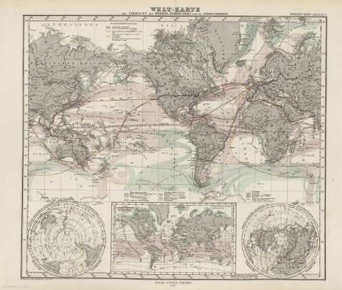
Title: Welt - Karte : Zur Ubersicht der Meeres - Strömungen und des Schnellverkehrs : [Karte] / Entworfen & gez. Herm. Berghaus 1867
Author: Berghaus, Hermann, 1828-1890
Edición: [Ed. 1867], Nachtr b. 1878
Material or type of resouce Area: Escala [ca. 1:101010101], 1 [= 0,11 cm] (O80 -E80 /N80 -S80)
Publication: Gotha [Alemania] : Justus Perthes, 1879
Physical description: 1 mapa : col. ; 34x39 cm, en h. de 39x48 cm, pleg. en 39x24 cm
Content type: Imagen cartográfica
Media type: computadora
Carrier type: recurso en línea
Notes: Constan ademas coordenadas según el meridiano de París y de Ferro
Leyenda de signos utilizados
Inserta : 2 planisferios y 'Linien Cleicher Temperatur der Meeres - flache im Kaltesten Monat'
En el margen superior derecho : "Stieler's Hand-Atlas Nº 7"
Copia digital . España : Ministerio de Cultura y Deporte. Subdirección General de Coordinación Bibliotecaria, 2010
Other titles: En: Hand atlas : über alle Theile der Erde und über das Weltgebäude. - Gotha [Alemania R.D.] : Justus Perthes, [1879]. - N 7
Materia / lugar / evento: Mareas
Vientos
Distribución de las temperaturas
Cables submarinos
Mundo - Mapas
Other authors: Stieler, Adolf, 1775-1836
Justus Perthes (Firma)
Related titles: Mundo. Mapas físicos. 1879 (1867). 1:101010101
UDC: 912:911.2]:[551.466:551.55:536.5:654.1:621.315.2:527.6](100)'1867'
(100)
Type of publication:
Maps
Rights:
