Nordost-Afrika und Arabien im Maassstabe 1:12.500.000


 Maps, plans and nautical charts
Nordost-Afrika und Arabien im Maassstabe 1:12.500.000 (1879)
- Petermann, Augustus, 1822-1878
Maps, plans and nautical charts
Nordost-Afrika und Arabien im Maassstabe 1:12.500.000 (1879)
- Petermann, Augustus, 1822-1878
 Disponible Holdings
 Section: Maps, plans and nautical charts
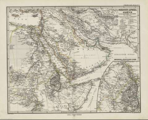
Title: Nordost-Afrika und Arabien im Maassstabe 1:12.500.000 / Von A. Petermann ; Bearbeitet v. Fr. Hanemann ; Gest. v. E. Kuhn ; Terrain v. A. Kramer
Author: Petermann, Augustus, 1822-1878
Material or type of resouce Area: 1:12.500.000 (E 22 -E 70 /N 38 -N 02)
Publication: Gotha : Justus Perthes, 1879
Physical description: 1 mapa : col. ; 33 x 41 cm, en h. de 39 x 48 cm, pleg. en 39 x 24 cm
Content type: Imagen cartográfica
Media type: computadora
Carrier type: recurso en línea
Notes: Coordenadas referidas al meridiano de París e Hierro
Relieve representado por normales
Leyenda de signos utilizados
Inserta: Abessinien und Agyptischer Sudan.- Escala 1:7500000
En el margen superior derecho : "Stieler's Hand-Atlas Nº 70"
Copia digital . España : Ministerio de Cultura y Deporte. Subdirección General de Coordinación Bibliotecaria, 2010
Other titles: En: Hand atlas : über alle Theile der Erde und über das Weltgebäude. - Gotha [Alemania R.D.] : Justus Perthes, [1879]. - N. 70
Other authors: Stieler, Adolf, 1775-1836
Hanemann, Fritz, 1847-1877
Kühn. E., fl. 1879
Kramer, A., fl. 1879
Justus Perthes (Firma)
Related titles: AFRICA. NE. Mapas generales. 1:12500000 (1879)
UDC: 912:341.222(6-18+5-011)'1979'
6-18
5-011
Type of publication:
Maps
Rights:
