Fluss - und Bergkarte von Deutschland und den Anliegenden...


 Maps, plans and nautical charts
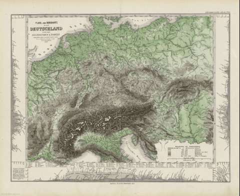
Fluss - und Bergkarte von Deutschland und den Anliegenden Ländern : [karte] (1879)
- Stieler, Adolf, 1775-1836
Maps, plans and nautical charts
Fluss - und Bergkarte von Deutschland und den Anliegenden Ländern : [karte] (1879)
- Stieler, Adolf, 1775-1836
 Disponible Holdings
 Section: Maps, plans and nautical charts
Title: Fluss - und Bergkarte von Deutschland und den Anliegenden Ländern : [karte] / entworfen v. gez. von Adolf Stieler 1820
Author: Stieler, Adolf, 1775-1836
Edición: Neve vermehrte Aufl. 1857/Herm. Berghaus
Material or type of resouce Area: Escala 1:4.625.000
Publication: Gotha [Alemania] : Justus Perthes, 1879
Physical description: 1 mapa : col. ; 32x41 cm, en h. de 39x48 cm, pleg. en 39x24 cm
Content type: Imagen cartográfica
Media type: computadora
Carrier type: recurso en línea
Notes: Constan coordenadas sin especificar meridiano
Relieve por sombreado
Leyenda de signos utilizados
Inserta 3 mapas de altitudes
En el margen superior derecho : "Stieler's Hand-Atlas Nº 16"
Copia digital . España : Ministerio de Cultura y Deporte. Subdirección General de Coordinación Bibliotecaria, 2010
Other titles: En: Hand atlas : über alle Theile der Erde und über das Weltgebäude. - Gotha [Alemania R.D.] : Justus Perthes, [1879]. - Nº 16
Other authors: Berghaus, Hermann, 1828-1890
Justus Perthes (Firma)
Related titles: Europa. Central. Mapas físicos. 1879. 1:4625000 (1857)
UDC: (4-191.2)
Type of publication:
Maps
Rights:
