Égypte et Syrie : [carte de campagne pour l'expedition de...


 Maps, plans and nautical charts
Égypte et Syrie : [carte de campagne pour l'expedition de 1798] (1870)
- Duvotenay, Thunot, 1796-1875
Maps, plans and nautical charts
Égypte et Syrie : [carte de campagne pour l'expedition de 1798] (1870)
- Duvotenay, Thunot, 1796-1875
 Disponible Holdings
 Section: Maps, plans and nautical charts
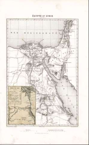
Title: Égypte et Syrie : [carte de campagne pour l'expedition de 1798] / Dressée par Th. Duvotenay, Geographe ; gravée par Ch Dyonnet
Author: Duvotenay, Thunot, 1796-1875
Material or type of resouce Area: Escala [1:4.166.666]
Publication: [París] : Publié par Furne, [1870] (Imp. en Taille douce de Lemercier rue de Seine 57)
Physical description: 1 mapa ; 31x21 cm, en h. de 43x28 cm
Content type: Imagen cartográfica
Media type: computadora
Carrier type: recurso en línea
Notes: Coordenadas : E25 50'-E34 00'/N34 00'-N23 00'. Meridiano de París
Escala gráfica además en leguas comunes de Francia
Relieve : sombreado
Copia digital . España : Ministerio de Cultura y Deporte. Subdirección General de Coordinación Bibliotecaria, 2010
Inserta : Canal de Suez / E. Bureau
Materia / lugar / evento: Mapas militares
Geografía militar
Cuencas hidrográficas
Egipto
Israel
Líbano
Arabia Saudí
Other authors: Dyonnet, Charles
Bureau, Édouard, 1830-1918
Furne, 1824-1880
Imprimerie Lemercier et cie
Related titles: Oriente Medio. Mapas Militares. [1870]. Ca. 1:4.166.666
UDC: 912:355]:355.47
912:911.2:556.51(620+569.4+569.3+532)'1798'
620
(569.4)
569.3
532
Type of publication:
Maps
Rights:
