The Delta of the Ganges with the adjacent countries on...


 Maps, plans and nautical charts
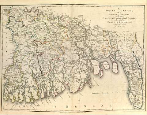
The Delta of the Ganges with the adjacent countries on the East : comprending the southern inland navigation
- Rennell, James, 1742-1830
Maps, plans and nautical charts
The Delta of the Ganges with the adjacent countries on the East : comprending the southern inland navigation
- Rennell, James, 1742-1830
Section: Maps, plans and nautical charts
Title: The Delta of the Ganges with the adjacent countries on the East : comprending the southern inland navigation / Inscribed to Francis Russell Esqr. By his affecto. Friend J. Rennell
Author: Rennell, James, 1742-1830
Material or type of resouce Area: Escala [ca. 1:748.534]. 40 Millas Inglesas [= 8'6 cm]
Physical description: 1 mapa : col. ; 49 x 62 cm
Content type: Imagen cartográfica
Media type: computadora
Carrier type: recurso en línea
Notes: Divisiones administrativas diferenciadas por líneas de colores
Red hidrográfica y de caminos
Arbolado
Orientado con lis
Márgenes graduados
Meridiano de origen: Calcuta
Relieve por montes de perfil y sombreado
Toponimia
Copia digital. Madrid : Ministerio de Cultura, 2010
Other titles: En: A Bengal atlas : containing maps of the theatre of war and commerce on that side of Hindoostan. - Inglaterra : [Editor no identificado], 1780. - [Lám. 1]
Materia / lugar / evento: Mapas generales
Núcleos de población
Navegación marítima
Rutas comerciales
Mares
Montañas
Ríos
1780
Bengala (Golfo)
India
Ganges (Río)
Other authors: Russell, Francis
Related titles: Ganges (India) (Delta) (Río). Mapas generales. 1780
UDC: (540)
(282.253.21)"1780"
Type of publication:
Maps
Rights:
