Wind and current chart


 Maps, plans and nautical charts
Wind and current chart (1849-1856)
- Maury, Matthew Fontaine, 1806-1873
Maps, plans and nautical charts
Wind and current chart (1849-1856)
- Maury, Matthew Fontaine, 1806-1873
 Disponible Holdings
 Section: Maps, plans and nautical charts
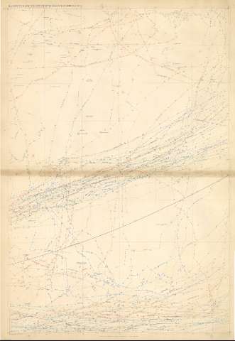
Title: Wind and current chart / M.F. Maury L.L.D. Lieut. U.S. Navy superin'dt of U.S.N. Observatory Washington
Author: Maury, Matthew Fontaine, 1806-1873
Material or type of resouce Area: Varias escalas
Publication: Washington : United States Hydrographical Office, 1849-1856
Physical description: 1 atlas (2 v. ([136] h.) : 68 map., col. y n. ; 69 x 52 cm
Content type: Imagen cartográfica
Media type: computadora
Carrier type: recurso en línea
Notes: Escalas halladas por grado de meridiano de diferente medida en cada mapa : Desde 0,26 hasta 6,3 cm ; la mayoría 2 cm
Cada mapa presenta una materia específica : Vientos, corrientes marinas, temperatura del agua, meteorología, previsión del tiempo y zonas balleneras
Están coloreados o delineados en color a excepción de los gráficos
Título tomado del lomo
Vol. 1 Oceáno Atlántico.- [68]h : 34 map. col. y n. -- vol. 2 Océano Pacífico y Océano Indico.- [68] h. : 34 map. col. y n.
Included records: A Chart showing the favorite resort of the sperm and right whale . - [Washington] : United States Hydrographical Office, 1853
Mary's wind & current chart Indian Ocean : Series A. N° 7. - [Washington] : United States Hydrographical Office, 1856
[...] Ver todos los registros incluidos (68)
Materia / lugar / evento: Pacífico - S.XVIII - Mapas
Índico - S.XVIII - Mapas
Genre / form: Cartas náuticas
Mapas meteorológicos
Other authors: Estados Unidos. Hydrographic Office
Related titles: Mundo. Vientos (1849-1856)
UDC: (100)
Type of publication:
Maps
Rights:
Préstamo:
 Disponible sólo para consulta en sala
