Mary's wind & current chart Indian Ocean : Series A. N° 7


 Maps, plans and nautical charts
Mary's wind & current chart Indian Ocean : Series A. N° 7 (1856)
- Maury, Matthew Fontaine, 1806-1873
Maps, plans and nautical charts
Mary's wind & current chart Indian Ocean : Series A. N° 7 (1856)
- Maury, Matthew Fontaine, 1806-1873
 Disponible Holdings
 Section: Maps, plans and nautical charts
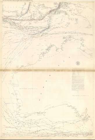
Title: Mary's wind & current chart Indian Ocean : Series A. N° 7 / [M.F. Maury] ; Tracks projected by Lt. G.P. Welsh, U.S.N
Author: Maury, Matthew Fontaine, 1806-1873
Material or type of resouce Area: Escala [ca. 1:5555555] (E 110°00'--E 140°00'/S 0°00'--S 40°00')
Publication: [Washington] : United States Hydrographical Office, 1856
Physical description: 1 mapa : col. ; 89 x 61 cm
Content type: Imagen cartográfica
Media type: computadora
Carrier type: recurso en línea
Notes: Océanos Índico y Pacífico, Serie A, Nº 38
Mapa que representa la intensidad y dirección de los vientos en el E. del océano Indico : mares de Java, Banda y Arafura, y costas australianas
Indica la dirección de los vientos, su nombre y fecha
Presenta además datos de corrientes, temperatura del agua y declinación magnética
Escala hallada según un grado de meridiano = 2 cm
Clave de signos y colores
Delineado ennegro, azul, verde y carmín
Other titles: En: Wind and current chart. - Washington : United States Hydrographical Office, 1849-1856. - 38
Other authors: Estados Unidos. Hydrographic Office
Related titles: Índico (Océano). Vientos. 1:5555555 (1856)
UDC: 912:551.55]:551.465]:551.526(267.7)"1856"
267.7
Type of publication:
Maps
Rights:
Préstamo:
 Disponible sólo para consulta en sala
