A New Map of the Western Parts of Virginia, Pennsylvania,...


 Maps, plans and nautical charts
A New Map of the Western Parts of Virginia, Pennsylvania, Maryland and North Carolina : comprehending the River... (1778)
Maps, plans and nautical charts
A New Map of the Western Parts of Virginia, Pennsylvania, Maryland and North Carolina : comprehending the River... (1778)
 Disponible Holdings
 Section: Maps, plans and nautical charts
Uniform title: Estados Unidos. Cuencas hidrográficas (1778). 1:1300000
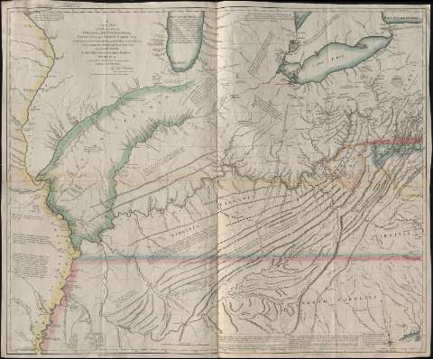
Title: A New Map of the Western Parts of Virginia, Pennsylvania, Maryland and North Carolina : comprehending the River Ohio, and all the Rivers, which fall into it, Part of the River Mississippi, the Whole of the Illinois River, Lake Erie, Part of the Lakes Huron, Michigan etc. And all the Country bordering on these Lakes and Rivers / by Tho. Hutchins ; engraved by J. Cheevers
Material or type of resouce Area: Escala [ca. 1:1.300.000], 10 miles [= 12,4 cm]
Publication: London : T. Hutchins, 1778
Physical description: 1 mapa : col. ; 91 x 109 cm
Content type: Imagen cartográfica
Media type: computadora
Carrier type: recurso en línea
Notes: Coordenadas referidas al meridiano de Londres (O 93º06'-O 79º22'/N 43º40'-N 33º40') y al meridiano de Filadelfia. Red geográfica de 1º en 1º. Orientado con lis en rosa de 16 vientos. Indica ángulo de declinación magnética
Relieve de perfil
Coloreado en varios colores
Notas explicativas por todo el mapa
Materia / lugar / evento: Cuencas hidrográficas
1778
Carolina del Norte
Virginia
Pensilvania
Maryland
Estados Unidos
Other authors: Hutchins, Thomas, 1730-1789
Cheevers, John
UDC: 73-11
Type of publication:
Maps
Rights:
Préstamo:
Disponible
