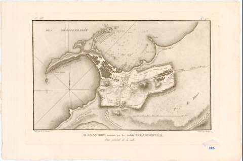
Alexandrie, nummée par les Arabes : Eskandéryéh : Plan...


 Maps, plans and nautical charts
Alexandrie, nummée par les Arabes : Eskandéryéh : Plan général de la Ville (182-?)
Maps, plans and nautical charts
Alexandrie, nummée par les Arabes : Eskandéryéh : Plan général de la Ville (182-?)
 Disponible Holdings
 Section: Maps, plans and nautical charts
Uniform title: ALEJANDRIA (Egipto). Planos de población. 1:20000 (182-?)
Title: Alexandrie, nummée par les Arabes : Eskandéryéh : Plan général de la Ville / Gravé par Berlin ; levé par L.F. Cassas
Material or type of resouce Area: [Ca. 1:20.000], 100 Toises [= 11,5 cm]
Publication: [France? : [Editor no identificado], 182-?]
Physical description: 1 mapa ; 25 x 40 cm en h. de 36 x 54 cm
Content type: Imagen cartográfica
Media type: computadora
Carrier type: recurso en línea
Notes: Orientado con flecha en nudo de rumbos
Relieve representado por sombreado. Sondas batimétricas
En el margen superior derecho: "N 47". En el superior izquierdo: "3e. Ve."
Procede de la "Colección Rico y Sinobas", n. 185
Other authors: Cassas, Louis Francois
Berlin (grab)
UDC: 912:314(620 Alejandria)'1820/1829'(084.3)
620 Alejandria
Type of publication:
Maps
Rights:
Préstamo:
Disponible
