Süd-America : [generalkarte]


 Maps, plans and nautical charts
Süd-America : [generalkarte] (1879)
- Stülpnagel, Friedrich von, 1786-1865
Maps, plans and nautical charts
Süd-America : [generalkarte] (1879)
- Stülpnagel, Friedrich von, 1786-1865
 Disponible Holdings
 Section: Maps, plans and nautical charts
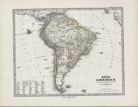
Title: Süd-America : [generalkarte] / entworfen v. gezeichnet von F. von Stulpnagel ; C. Stier sc
Edición: rev, v. Hm. Bgs.
Material or type of resouce Area: 1:27.750.000
Publication: Gotha [Alemania] : Justus Perthes, 1879
Physical description: 1 mapa : col. ; 30 x 37 cm en h. de 39 x 48 cm, pleg. en 39 x 24 cm
Content type: Imagen cartográfica
Media type: computadora
Carrier type: recurso en línea
Notes: Coordenadas referidas al meridiano de Hierro (O 80 -O 10 /N 20 -S 46)
Relieve representado por normales
Figura leyenda con el nombre de los diferentes estados
En el margen superior derecho : "Stieler's Hand-Atlas Nº 88"
Copia digital . España : Ministerio de Cultura y Deporte. Subdirección General de Coordinación Bibliotecaria, 2010
Other titles: En: Hand atlas : über alle Theile der Erde und über das Weltgebäude. - Gotha [Alemania R.D.] : Justus Perthes, [1879]. - N. 88
Materia / lugar / evento: Mapas generales
América del Sur
Other authors: Stier, Carl, -1875
Stieler, Adolf, 1775-1836
Berghaus, Hermann, 1828-1890
Justus Perthes (Firma)
Related titles: AMERICA DEL SUR. Mapas generales (1879). 1:27750000
UDC: 912:341.222(8)'1887'
8
Type of publication:
Maps
Rights:
