Spanien und Portugal : Ubersicht : [generalkarte]


 Maps, plans and nautical charts
Spanien und Portugal : Ubersicht : [generalkarte] (1879)
- Vogel, C
Maps, plans and nautical charts
Spanien und Portugal : Ubersicht : [generalkarte] (1879)
- Vogel, C
 Disponible Holdings
 Section: Maps, plans and nautical charts
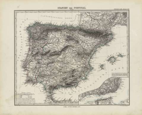
Title: Spanien und Portugal : Ubersicht : [generalkarte] / Bearbeitet von C. Vogel ; Gestochen situation de schrift v. C. Metzeroth ; terrain von W. Weiler
Material or type of resouce Area: Escala 1:3.700.000
Publication: Gotha [Alemania] : Justus Perthes, 1879
Physical description: 1 mapa : col. ; 31x37 cm, en h. de 39x48 cm, pleg. en 39x24 cm
Content type: Imagen cartográfica
Media type: computadora
Carrier type: recurso en línea
Notes: Coordenadas : O8 -O22 /N44 -N36 . Meridiano de Ferro. Constan ademas coordenadas según el meridiano de París
Relieve : líneas perpendiculares normales
Leyenda de signos utilizados
Inserta : Mapa ampliado de Lisboa. - Escala 1:150000
En el margen superior derecho : "Stieler's Hand-Atlas Nº 38"
Copia digital . España : Ministerio de Cultura y Deporte. Subdirección General de Coordinación Bibliotecaria, 2010
Other titles: En: Hand atlas : über alle Theile der Erde und über das Weltgebäude. - Gotha [Alemania R.D.] : Justus Perthes, [1879]. - N 38
Other authors: Stieler, Adolf, 1775-1836
Metzeroth, Carl, 1824-1875
Weiler, Wilhelm Robert, 1825-1895
Justus Perthes (Firma)
Related titles: España. Mapas generales (1879). 1:3700000
UDC: 912:341.222(460+469-2/-5)'1879'
460
469
Type of publication:
Maps
Rights:
