Indien & Inner-Asien : in 2 blättern im massstabe von 1...


 Maps, plans and nautical charts
Indien & Inner-Asien : in 2 blättern im massstabe von 1:7.500.000 (1879)
- Petermann, Augustus, 1822-1878
Maps, plans and nautical charts
Indien & Inner-Asien : in 2 blättern im massstabe von 1:7.500.000 (1879)
- Petermann, Augustus, 1822-1878
 Disponible Holdings
 Section: Maps, plans and nautical charts
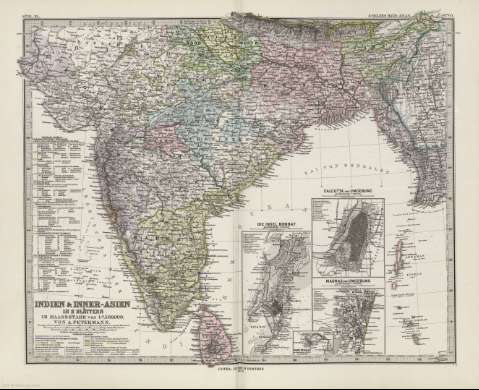
Title: Indien & Inner-Asien : in 2 blättern im massstabe von 1:7.500.000 / Von A. Petermann ; Bearbeitet von E. Debes & H. Habenich
Author: Petermann, Augustus, 1822-1878
Material or type of resouce Area: 1:17.500.000 (E 70 50'-E 97 20'/N 48 00'-N 6 00')
Publication: Gotha [Alemania]] : Justus Perthes, 1879
Physical description: 1 mapa en 2 h. : col. ; 33 x 41 cm en h. de 39 x 48 cm, pleg. en 39 x 24 cm
Content type: Imagen cartográfica
Media type: computadora
Carrier type: recurso en línea
Notes: Coordenadas referidas a los meridianos de París y de Hierro
Relieve representado por normales
Leyenda de signos utilizados
Inserta: Calcutta und Umgebung [Karte]. 1:150000 ; Madras und Umgebung. 1:150000 ; Die insel Bombay. 1:150000 ; Point de Galle. 1:150000
En el margen superior derecho : "Stieler's Hand-Atlas Nº 63"
Copia digital . España : Ministerio de Cultura y Deporte. Subdirección General de Coordinación Bibliotecaria??, 2010
Other titles: En: Hand atlas : über alle Theile der Erde und über das Weltgebäude. - Gotha [Alemania R.D.] : Justus Perthes, [1879]. - N. 63, 64
Materia / lugar / evento: Mapas generales
Calcuta (India)
Bombay (India)
India
China
Tíbet
Sri Lanka
Asia
Other authors: Debes, Ernst, 1840-1923
Habenicht, Hermann, 1844-1917
Stieler, Adolf, 1775-1836
Justus Perthes (Firma)
Related titles: Asia. 1:7500000
UDC: 912:341.222(548.7+515+540+510)'1842'
540
548.7
515
510
Type of publication:
Maps
Rights:
