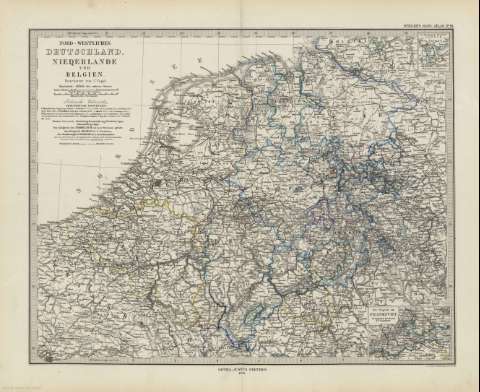
Nord-Westliches Deutschland, Niederlande und Belgien


 Maps, plans and nautical charts
Nord-Westliches Deutschland, Niederlande und Belgien (1879)
- Vogel, C
Maps, plans and nautical charts
Nord-Westliches Deutschland, Niederlande und Belgien (1879)
- Vogel, C
 Disponible Holdings
 Section: Maps, plans and nautical charts
Title: Nord-Westliches Deutschland, Niederlande und Belgien / bearbeitet von C. Vogel ; gest. v. W. Alt, berge von E. Kratz
Material or type of resouce Area: Escala 1:1.850.000
Publication: Gotha [Alemania] : Justus Perthes, 1879
Physical description: 1 mapa : col. ; 32x40 cm, en h. de 39x48 cm, pleg. en 39x24 cm
Content type: Imagen cartográfica
Media type: computadora
Carrier type: recurso en línea
Notes: Coordenadas (E19º-E30º/N54º-N49º). Constan además coordenadas según el meridiano de París. Meridiano de Ferro
Relieve representado por normales
Leyenda de signos utilizados
Inserta: "Das Oldenbuirgische Fürstenthum" -- "Die Gegend um Frankfurt"
En el margen superior derecho : "Stieler's Hand-Atlas Nº 19"
Copia digital . España : Ministerio de Cultura y Deporte. Subdirección General de Coordinación Bibliotecaria, 2010
Other titles: En: Hand atlas : über alle Theile der Erde und über das Weltgebäude. - Gotha [Alemania R.D.] : Justus Perthes, [1879]. - N 19
Materia / lugar / evento: Mapas generales
Bélgica
Alemania
Luxemburgo
Francia
Related titles: EUROPA. NO. Mapas generales (1879). 1:1850000
UDC: (4-16)
Type of publication:
Maps
Rights:
