Trade wind chart of the Atlantic Ocean


 Maps, plans and nautical charts
Trade wind chart of the Atlantic Ocean (1851)
- Maury, Matthew Fontaine, 1806-1873
Maps, plans and nautical charts
Trade wind chart of the Atlantic Ocean (1851)
- Maury, Matthew Fontaine, 1806-1873
 Disponible Holdings
 Section: Maps, plans and nautical charts
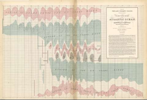
Title: Trade wind chart of the Atlantic Ocean / cby M.F. Maury, L.L.D. Lieut U.S.N. Superintendent National Observatory ; compiled by Lt.E.J. Dehaven. U.S.N. from Materials in the Bureau of Ordnance and Hydrography. Commodore Chs. Morris, chief of Bureau
Author: Maury, Matthew Fontaine, 1806-1873
Edición: Reprinted April 1858
Material or type of resouce Area: Escala indeterminada
Publication: [Washigton] : United States Hydrographical Office, 1851
Physical description: 1 mapa : col. ; 59 x 90 cm
Content type: Imagen cartográfica
Media type: computadora
Carrier type: recurso en línea
Notes: Océano Atlántico, Series A, Nº 9
Gráfico que muestra las zonas y meses en que soplan los alisios sobre el Atlántico
Leyenda explicativa
Coloreadas las distintas zonas en verde, carmín y gris
Other titles: En: Wind and current chart. - Washington : United States Hydrographical Office, 1849-1856. - 9
Related titles: Atlántico (Océano). Vientos. Escala indeterminada (1851)
UDC: 912:551.55(261)"1851"
(261)
Type of publication:
Maps
Rights:
Préstamo:
 Disponible sólo para consulta en sala
