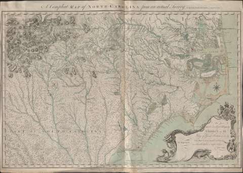
Compleat map of Norh-Carolina from an actual survey


 Disponible Holdings
 Section: Maps, plans and nautical charts
Title: Compleat map of Norh-Carolina from an actual survey / by Captn. Collet. Governor. of Fort Johnfton ; Engraved by I. Bayly
Material or type of resouce Area: Escala [ca. 1:548.642], 30 british miles 69 1/2 to a degrée [= 8,8 cm]
Publication: London : Publishid according to Act of Parliament by S. Hooper, N° 25 Ludgate Hill , May the 1st. 1770
Physical description: 1 mapa : col. ; 77 x 110 cm
Content type: Imagen cartográfica
Media type: computadora
Carrier type: recurso en línea
Notes: Dedicatoria: "To His most Excellent Majesty George the IIId. ..." firmada y rubricada por el autor
Escala gráfica de 30 millas geométricas de 60 al grado [=10,6 cm]. Coordenadas referidas a un meridiano desconocido (O 345°00'-E 25°00'/N 36°50'-N 36°45'). Orientado con lis en rosa de 8 vientos
Relieve representado por normales
Indica veriles, fondeaderos y sondas batimétricas
En el ángulo superior izquierdo: "82°19' W. Longd. from London 6 degrees of long. from Corrituels Inlet".
Señala vegetación, masas forestales, fortificaciones, núcleos de población de distintas categoría, etc.
Dedicatoria enmarcada en cartela decorada con figuras humanas, de animales y plantas rodeada por una greca con guirnaldas
Materia / lugar / evento: Mapas generales
Carolina del Norte
UDC: 756
Type of publication:
 Maps
Maps
Rights:
Préstamo:
Disponible
