Itinerario de Puentelarrá á la Vta. de Leza


Section: Maps, plans and nautical charts
Uniform title: AMURRIO (Álava). Itinerarios topográficos. 1:20.000 (1857)
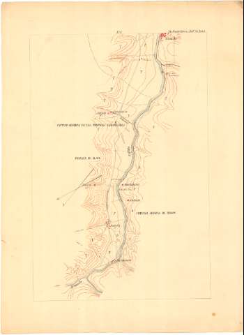
Title: Itinerario de Puentelarrá á la Vta. de Leza / Levantado por el Comandante y Capitán del Cuerpo de E.M. del Ejército D. José Carrillo y D. Gil Arévalo. Año 1857
Material or type of resouce Area: Escala [ca. 1:20000]
Physical description: 1 mapa en 2 h. : ms., col. ; 77,4 x 56,6
Notes: Comprende los partidos judiciales de Amurrio y Vitoria, en la provincia de Alava, de Miranda de Ebro en la provincia de Burgos, y de Haro, en La Rioja, pasando entre otras, por las poblaciones de Fonteche, Comunión, Miranda de Ebro, Ircio, Haro y Briones
Título y mención de responsabilidad tomados de la hoja que agrupa a las que conforman este itinerario
Orientadas al norte geográfico y magnético
Relieve por curvas de configuración croquisadas sin cotas
Mención del número de vecinos de los núcleos de población más significativos
Se corresponde con la memoria de sig. C-37 N°11
Materia / lugar / evento: Itinerarios topográficos
1857
Álava
Burgos (Provincia)
Haro
País Vasco
Castilla y León
La Rioja (Comunidad Autónoma)
Other authors: Carrillo, José
Arévalo y Escudero, Gil
España. Ejército de Tierra. Cuerpo de Estado Mayor
UDC: 912:528.42(466.311)(466.313)(463.417)(463.515)"1857"
466.311
466.313
463.417
463.515
Type of publication:
 Maps
Maps
Rights:
Préstamo:
 Disponible
