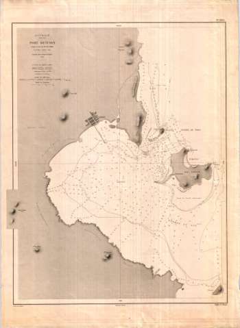
Australie côte est, Port Denison


 Disponible Holdings
 Section: Maps, plans and nautical charts
Title: Australie côte est, Port Denison / d'après le levé de Mr. J. W. Smith de la Marine Anglaise ; gravé par Delaune ecrit por Vialard
Author: Smith, J. W
[Australie côte est, Port Denison (1860)] All editions
Characteristics of the edition: 1878. 1:18500. Francés
Material or type of resouce Area: Escala [ca. 1:18.500]
Publication: [París] : Dépôt des Cartes et Plans de la Marine, 1878
Physical description: 1 mapa ; 62 x 48 cm
Content type: Imagen cartográfica
Media type: computadora
Carrier type: recurso en línea
Notes: Aparece número referencial en ángulo superior derecho
Comprende además las islas Stone y Thomas
Escala gráfica de 10 cm equivalente a una milla y de 4,7 cm equivalente a 30'' de latitud
Indica sondas batimétricas, veriles de sonda, enfilaciones y fondeaderos
Orientados los cuatro puntos cardinales
Representación del relieve por normales
Señala el grado de declinación magnética
Reproducción digital
Genre / form: Cartas náuticas
Documentos archivísticos
Other authors: Vialard
Delaune, E
Francia. Dépôt des Cartes et Plans de la Marine
España. Dirección de Hidrografía. Expediciones a Indias, productor
Museo Naval (Madrid). Archivo. Documentos gráficos, Mapas
Type of publication:
 Maps
Maps
Rights:
Préstamo:
Disponible
