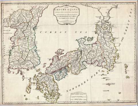
The Empire of Japan : divided into seven principal parts...


 Maps, plans and nautical charts
The Empire of Japan : divided into seven principal parts and subdivided into sixty six Kingdoms : with the Kingdom... (as the Act directs 1st. January 1790)
Maps, plans and nautical charts
The Empire of Japan : divided into seven principal parts and subdivided into sixty six Kingdoms : with the Kingdom... (as the Act directs 1st. January 1790)
 Disponible Holdings
 Section: Maps, plans and nautical charts
Uniform title: The Empire of Japan. 1790. Inglés. 1:3.090.000
Title: The Empire of Japan : divided into seven principal parts and subdivided into sixty six Kingdoms : with the Kingdom of Corea, from Kempfer and the Portuguese
Material or type of resouce Area: Escala [ca. 1:3.090.000]
Publication: London : Printed for Robt. Sayer N°53, in Fleet Street, as the Act directs 1st. January 1790
Physical description: 1 mapa : col. ; 48 x 64 cm
Content type: Imagen cartográfica
Media type: computadora
Carrier type: recurso en línea
Notes: Escalas gráficas de 40 leguas marinas [= 7,2 cm], 60 leguas japonesas [= 6,6 cm] y 140 millas inglesas [= 7,5 cm]. Coordenadas referidas al meridiano de Hierro (E 140°20'00''-E 163°10'00''/N 4230'00''-N 30°05'00''). Red geográfica de 5° en 5°
Falta la representación de la mayor parte de la isla Hokkaido
Límites entre las divisiones administrativas diferenciados por colores
Relieve de perfil
Título y escalas gráficas enmarcados en cartelas
Reproducción digital
Materia / lugar / evento: Divisiones administrativas
1790
Islas
Corea del Norte
Corea del Sur
Genre / form: Documentos archivísticos
Mapas generales
Other authors: Sayer, Robert, 1725-1794
España. Dirección de Hidrografía. Expediciones a Indias, productor
Museo Naval (Madrid). Archivo. Documentos gráficos, Mapas
Type of publication:
Maps
Rights:
Préstamo:
Disponible
