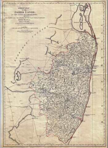
A New Map of the Jaghir Lands, on the coast of Coromandel...


 Maps, plans and nautical charts
A New Map of the Jaghir Lands, on the coast of Coromandel : or The Territory belonging to the East India Company... (1783)
Maps, plans and nautical charts
A New Map of the Jaghir Lands, on the coast of Coromandel : or The Territory belonging to the East India Company... (1783)
 Disponible Holdings
 Section: Maps, plans and nautical charts
Title: A New Map of the Jaghir Lands, on the coast of Coromandel : or The Territory belonging to the East India Company round Madras from and Actual Survey in the Possession of the Company
Material or type of resouce Area: Escala [ca. 1:254.000]
Publication: London : Published for Robert Sayer and john Bennett, as the Act Directs, 1783
Physical description: 1 mapa : col. ; 71 x 51 cm
Content type: Imagen cartográfica
Media type: computadora
Carrier type: recurso en línea
Notes: Comprende la parte central de la costa oriental de la India, entre el lago Pulicat y el rio Marakkanam
Escala gráfica de 20 millas inglesas [= 12'7 cm]. Coordenadas referidas al meridiano de Londres (E 79°23'--E 80°31'/N 13°51'--N 12°16'). Recuadro geográfico de 5° en 5°
Orografía de perfil
Reproducción digital
Genre / form: Documentos archivísticos
Mapas generales
Other authors: España. Dirección de Hidrografía. Expediciones a Indias, productor
Robert Sayer and John Bennett (Firma)
Museo Naval (Madrid). Archivo. Documentos gráficos, Mapas
Type of publication:
Maps
Rights:
Préstamo:
Disponible
