Carte de l'Inde


 Maps, plans and nautical charts
Carte de l'Inde (1752)
- Anville, Jean-Baptiste Bourguignon d' 1697-1782
Maps, plans and nautical charts
Carte de l'Inde (1752)
- Anville, Jean-Baptiste Bourguignon d' 1697-1782
 Disponible Holdings
 Section: Maps, plans and nautical charts
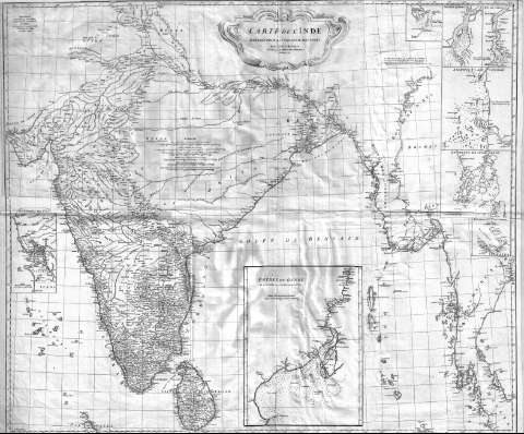
Title: Carte de l'Inde / dressée pour la Compagnie des Indes Par le Sr. D'Anville Sécrétaire de S.A.S. Mgr le Duc d'Orleans
Author: Anville, Jean-Baptiste Bourguignon d' 1697-1782
[Carte de l'Inde] All editions
Characteristics of the edition: 1752. 1:3100000. Español
Material or type of resouce Area: Escala [ca.1:3.100.000]
Publication: [París] : Guill. de la Haye, 1752
Physical description: 1 mapa en 2 h. ; 86 x 104 cm. en h. de 56 x 112 cm, pleg. en 56 x 42 cm
Content type: Imagen cartográfica
Media type: computadora
Carrier type: recurso en línea
Notes: Comprende la India, excepto su parte más septentrional, Sri Lanka, y las costas que asoman a la bahía de Bengala de Bangladesh, Birmania, Tailandia y Malasia
En : Anville, Jean Baptiste Bourguignon d' : "Atlas o Cartes Geographiques". 1786?, [map.22(1-2)]
Escalas gráficas de 80 leguas márinas de 20 al grado [= 14,2 cm], 80 leguas francesas de 2500 toesas, 100 coss de 1335 toesas, 100 grandes coss de 33 al grado, 100 coss comunes de 37 al grado y 25 Gos o Gau, equivalentes a 4 Coss cada uno. Coordenadas referidas al meridiano de Ferro (E 85°00'--E 120°00'/N 29°30'--N 5°30'). Red geográfica de 1° en 1°
Indica bajos en la costa
Inserta : "Negraïs". Escala [ca.1:1000000], 4 leguas marinas [= 2,1 cm]. "Riviére d'Aracan". Escala [ca.1:390000], 3 leguas de 25 al grado [=3,4 cm]. "Riv. de Sirian". Escala [ca.1:390000], 3 leguas de 25 al grado [= 3,4 cm]. "Archipiel de Merghi". Escala [ca.1:1600000], 10 leguas marinas de 20 al grado [= 3,5 cm]. "Environs de Yunk Selon". Escala [ca.1:1600000], 10 leguas marinas de 20 al grado [= 3,6 cm]. "Environs de Goa". Escala [ca.1:480000], 3 leguas marinas de 20 al grado [= 3,5 cm]. "Environs d'Asheam". Escala [ca.1:980000], 5 leguas marinas [= 2,85 cm]. "Entrée du Gange". Escala [ca.1:780000], 10 leguas marinas [= 7,1 cm]. Indican sondas batimétricas y veriles. Toponimia costera de los principales accidentes geográficos
Intercala varias notas explicativas que dan cuenta de las características más notables del área en él que se encuentran
Orografía de perfil
Reproducción digital
Materia / lugar / evento: Cartas náuticas
Bahías
1752
Sri Lanka
Bengala Occidental
Genre / form: Documentos archivísticos
Mapas generales
Other authors: Delahaye, Guillaume-Nicolas, 1727-1802
España. Dirección de Hidrografía. Expediciones a Indias, productor
Museo Naval (Madrid). Archivo. Documentos gráficos, Mapas
Type of publication:
Maps
Rights:
Préstamo:
Disponible
