Map of the provinces of Canada, New Beunswick, Nova...


 Mapas, planos y cartas náuticas
Map of the provinces of Canada, New Beunswick, Nova Scotia, Newfoundland and Prince Edward Island, with a large... (1853)
Mapas, planos y cartas náuticas
Map of the provinces of Canada, New Beunswick, Nova Scotia, Newfoundland and Prince Edward Island, with a large... (1853)
 Disponible Ejemplares
 Sección: Mapas, planos y cartas náuticas
Título uniforme: CANADA. Mapas generales. 1:910000 (1853)
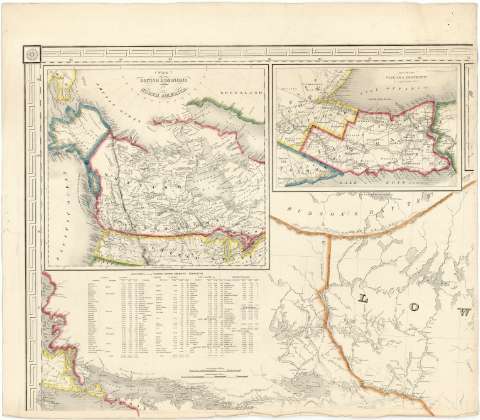
Título: Map of the provinces of Canada, New Beunswick, Nova Scotia, Newfoundland and Prince Edward Island, with a large section of the United States and exhibiting the boundary of the British Dominions in North America according to the Traties of 1842 & 6 / compiled from the latest and most approved Astronomical observations Authorities and recent surveys by Joseph Bouchette Depr. Survr. Generl. L.C
Área de datos: Escala [ca. 1:910000 ; proyección cónica conforme de Lambert] (O 84°00'--O 61°00'/N 50°00'--S 42°00')
Publicación: New York : engraved by Sherman & Smith, 1853
Descripción física: 1 mapa en 6 hoja : col. ; hoja de 67 x 77 cm
Tipo de contenido: Imagen cartográfica
Tipo de medio: computadora
Tipo de soporte: recurso en línea
Notas: Escalas gráficas de 30 millas geográficas [= 6,1 cm], 50 millas estatutarias inglesas [= 8,9 cm] y 15 leguas francesas [= 8,9 cm]
Relieve representado por normales
Tabla de signos convencionales, relación de autoridades consultadas para la construcción del mapa y datos estadísticos de las distintas provincias de Canadá
Límites entre las distintas provincias y países lavados en varios colores
Inserta: "Environs of Montreal". Escala [ca. 1:451670]; "Map pf Newfoundland". Escala [ca. 1:2923976]; "Map of Lake Superior : reduced from the hidrographical Survey of Capt. Bayfield R.N." Escala [ca. 1:2057611]; "Map of the Niagara district by Joseph Bonchette, DSG". Escala [ca. 1:4300000]; "The british dominions in North America". Escala [ca. 1:14224501]
Materia / lugar / evento: Mapas políticos
1853
Estados Unidos
Otros autores: Bonchette, Joseph
Sherman & Smith (Nueva York)
CDU: 912:32(71-35)"1853"
71
73-17
Tipo de publicación:
Mapas
Derechos:
Préstamo:
Disponible
