A chart of the Eaft Cooft of England from Loweftoff to...


 Maps, plans and nautical charts
A chart of the Eaft Cooft of England from Loweftoff to Scarborough, A] (1760 ?)
Maps, plans and nautical charts
A chart of the Eaft Cooft of England from Loweftoff to Scarborough, A] (1760 ?)
 Disponible Holdings
 Section: Maps, plans and nautical charts
Uniform title: INGLATERRA (Reino Unido). NE. Cartas náuticas. 1:200000 (1760)
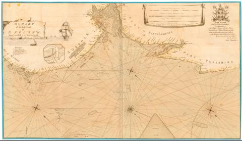
Title: A chart of the Eaft Cooft of England from Loweftoff to Scarborough, A] / Engravid by T.J. Woodman, by John Chandler
Material or type of resouce Area: Escala [ca. 1:200000], 10 English and French leguas 20 to a degree [= 27 cm]
Publication: London : Printed for David Steel Bookseller N. 1 Union Rau little Jover Hill, [1760 ?]
Physical description: 1 carta naútica : col. montado sobre tela ; 76x80 cm, pleg en 77x34 cm
Notes: Dedicatoria : 'This chart Having been honoured with the approbation of the right honourable the master wardens and Elder Brethren of the Troity House of Deplford Strond... John Chandler'
Escala Gráfica de 8 millas alemanas y danesas de 15 al grado [= 28 cm], 5 'Norway Common mile 10 in a Degree [= 27 cm] Orientado con lis en rosa de 8 vientos prolongados
Relieve representado por sondas batimétricas
Indica veriles, bajos fondeaderos, y dirección de las corrientes marinas con flecha
Tabla de signos convencionales para indicar los bancos de arena y dirección de las mareas
Nota sobre la altura que alcanzan las aguas con las diferentes mareas
Titulo enmarcado con motivos marinos Representación de 1 galera, 1 barco y escudo
Inserta : Blakeney Harbour. - [ca. 1:23000]
Materia / lugar / evento: Cartas náuticas
Costas
1760
Scarborough
Lowestoft
Other authors: Chandler, John
Woodman, T.J
Steel, David
UDC: 912:[551.46:551.468)(410-328 Inglaterra)'1760'
(410-Scarborough)
(410-Lowesttoft)
Type of publication:
Maps
Rights:
Préstamo:
Disponible
