Map of the country between Monterray, Tenn. and Corinth,...


 Maps, plans and nautical charts
Map of the country between Monterray, Tenn. and Corinth, Miss. : Showing the lines of intrechments made the routes... (189-?)
Maps, plans and nautical charts
Map of the country between Monterray, Tenn. and Corinth, Miss. : Showing the lines of intrechments made the routes... (189-?)
 Disponible Holdings
 Section: Maps, plans and nautical charts
Uniform title: Estados Unidos. E. Operaciones bélicas. 1891 (1862). 1:64373
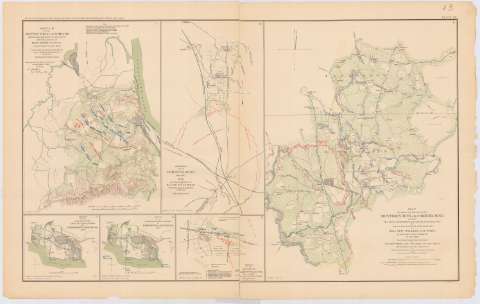
Title: Map of the country between Monterray, Tenn. and Corinth, Miss. : Showing the lines of intrechments made the routes followed by the U.S. Forces under the Conmand Maj. Genl. Halleck, U.S. Army, in adrance upon Corinth in May 1862 / Surveyed under the direction of Col. Geo. Thom A.D.C. And Chief of Topl. Engrs. Department of the Mississippi ; by lieuts. Fred. Schrraag, and C.L. Snanagenberg, Asst. top. Engrs. ; and drawn by Licut. Otto H. Martz, Asst. top. Engr
Material or type of resouce Area: Escala [ca. 1:64373], 2 miles [= 5 cm]
Publication: Washington : Government Printing Office, [189-?] (N.Y. [Nueva York] : Julius Bien & co.)
Physical description: 1 mapa : col. ; 41 x 31 cm en h. de 47 x 75 cm
Content type: Imagen cartográfica
Media type: computadora
Carrier type: recurso en línea
Notes: Relieve representado por normales
Indica los símbolos utilizados
Orientado con flecha
En el margen inferior: Series 1, Vol. 10
En : Atlas to accompany the Official Records of the Union and Confederate Armies 1861-1865. Plate 13, nº 6
Materia / lugar / evento: Guerra civil
Operaciones bélicas
Estrategia militar
Fortificaciones
Trincheras
1862
Monterey
Mississippi
Tennessee
Estados Unidos
Other authors: Scharaag, Fred Liert
Spagenberg, C. L
Thom colonel
Matz, Otto H
UDC: 912:355.4]:[355.4+355.43+623.1+357.1](768+762)'1862'
768
762
Type of publication:
Maps
Rights:
Préstamo:
Disponible
