General Kart over den Sydlige Deel Kongeriget Norge (Noregr)


 Maps, plans and nautical charts
General Kart over den Sydlige Deel Kongeriget Norge (Noregr) (1848 ?)
Maps, plans and nautical charts
General Kart over den Sydlige Deel Kongeriget Norge (Noregr) (1848 ?)
 Disponible Holdings
 Section: Maps, plans and nautical charts
Uniform title: Noruega. Mapas generales. 1:1000000 (1848)
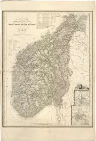
Title: General Kart over den Sydlige Deel Kongeriget Norge (Noregr) / af Carl B. Roosen ; Graveret paa staal af Malo, skriften af Pelicier i Paris
Material or type of resouce Area: Escala 1:1000000 ; [proyec. cónica]
Publication: ]Paris : Del saelges... hos Picquet, quai Contí, 17, [1848 ?]
Physical description: 1 mapa ; 85x66,5 cm en h. de 103x79,3 cm
Content type: Imagen cartográfica
Media type: computadora
Carrier type: recurso en línea
Notes: Presenta además perfil del terreno
Coordenadas referidas, al parecer, al meridiano de Hierro (E22#50'-E33#20'/N65#10'-N58#00'). Red geográfica de 1# en 1#
Relieve representado por sombreado
Tabla de signos convencionales para indicar limites administrativos de diferente categoría, núcleos de población, accidentes geográficos etc...
En la parte superior tabla de datos estadísticos
Sello en seco del Depósito de la Guerra
En el ángulo inferior derecho representación de león
Inserta : Frederikshald. - Escala 1:15000. Kristiania. - Escala [ca. 1:24700], 500 Allen [= 1,4 cm]
Materia / lugar / evento: Mapas generales
Divisiones administrativas
Topónimos antiguos
1848
Kristiansand
Other authors: Roosen, Carl B
Pelicier, T
Malo
Picket, Charles
UDC: 912(481-13)'1848'
481-13
Type of publication:
Maps
Rights:
Préstamo:
Disponible
