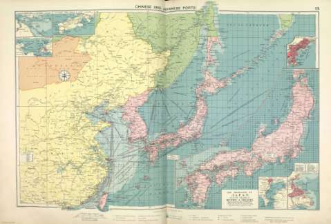
Chinese and Japanese ports


 Disponible Holdings
 Section: Maps, plans and nautical charts
Title: Chinese and Japanese ports
Author: Philip, George, 1870-1937
Material or type of resouce Area: Escala 1:10.000.000
Publication: [London] ; [Liverpool] : George Philip & Son, Ltd : The London Geographical Institute : Philip, Son & Nephew, [1922]
Physical description: 1 mapa ; 49 x 72 cm
Content type: Imagen cartográfica
Media type: computadora
Carrier type: recurso en línea
Notes: Copia digital. Madrid : Ministerio de Cultura, 2010
Inserta mapas de: Approaches to Shanghai ; Port Arthur &Dalny ; Wei-hai-wei ; Kiao-chow ; Kobe ; Tokio Bay ; Yokohama ; The mainland of Japan with the islands of Kiushiu and Shikoku
Other titles: En: Philip's Mercantile Marine Atlas. - [London] : Edited by George Philip [et al.], 1922. - Mapa 19
Materia / lugar / evento: Rutas marítimas - Mapas
Puertos - China - Mapas
Puertos - Japón - Mapas
Asia oriental - Mapas
Genre / form: Cartas náuticas
Atlas mundiales
Other authors: George Philip & Son
Merchant, Shippers, Exported and Ocean Travelles
London Geographical Institute
Related titles: Asia Oriental. Mapas generales. ca. 1922
UDC: (5-11)
Type of publication:
 Maps
Maps
Rights:
Préstamo:
 Disponible sólo para consulta en sala
