A New Map of Jamaica : In which the Several Towns, Forts,...


 Maps, plans and nautical charts
A New Map of Jamaica : In which the Several Towns, Forts, and Settlements... Harbours and Anchoring Places...... (1750?)
Maps, plans and nautical charts
A New Map of Jamaica : In which the Several Towns, Forts, and Settlements... Harbours and Anchoring Places...... (1750?)
 Disponible Holdings
 Section: Maps, plans and nautical charts
Uniform title: JAMAICA. Mapas generales. 1:232118 (1730-1749)
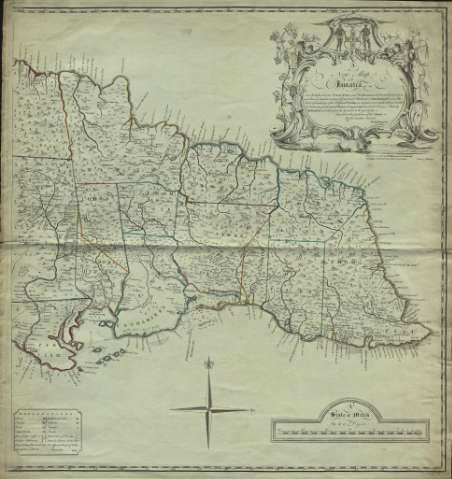
Title: A New Map of Jamaica : In which the Several Towns, Forts, and Settlements... Harbours and Anchoring Places... Parishes... / The greatest part Drawn or Corrected from actual Surveys Made by Mr. Sheffield and others, from the year 1730 to the year 1749 ; Inscrib'd to the Gentlemen of the Island By their humble Servant Patk Browne ; I Bayly Sculp
Material or type of resouce Area: Scale [ca. 1:232.118]. 30 miles 69 to a degree [= 20,8 cm]
Publication: London : Carington Bowles, St. Pauls Charch Yard, [1750?]
Physical description: 1 mapa en 2 h. : grab., col. ; 70 x 65,8 cm
Content type: Imagen cartográfica
Media type: computadora
Carrier type: recurso en línea
Notes: Márgenes graduados. Orientado con rosa de 4 vientos y lis
Relieve representado por montes de perfil. Costas sombreadas con un fino rayado. Divisiones administrativas diferenciadas por líneas de color. Hidrografía
Indica veriles, bajos, fondeaderos y sondas batimétricas
Tabla de símbolos convencionales para indicar fortificaciones, núcleos de población de distinta categoría, etc.
Título enmarcado en cartela barroca con pareja de nativos y la leyenda: "Indus uterque serviet uni"
Figura sólo una hoja
Materia / lugar / evento: Mapas generales
Divisiones administrativas
Poblaciones indígenas
Jamaica
Other authors: Sheffield
Bayly, John, fl. 1755-1794
Bowles, Carrington, 1724-1793
Browne, Patrick
UDC: 729.2
Type of publication:
Maps
Rights:
Préstamo:
Disponible
