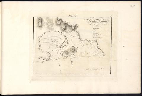
Puerto Antonio
Section: Maps, plans and nautical charts
Uniform title: Port Antonio (Jamaica, Puerto). Cartas náuticas. 1818 (1809)
Title: Puerto Antonio
Material or type of resouce Area: Escala [ca. 1:15.500]. 1/2 milla dividida en cables [= 6 cm]
Publication: [Madrid] : [Dirección de Trabajos Hidrográficos], [1818]
Physical description: 1 carta náutica : grab. ; 17,5 x 23,5 cm
Notes: En la parte superior: "Jamayca"
Esta carta aparecía como Nº 1 en la 4ª parte (Jamaica) del Cuaderno de Portulanos de América con 106 planos en el momento de su publicación (1809). En 1861 la Dirección de Hidrografía adjudica un número a cada una de las cartas del Portulano, en este caso el nº 421 (La Dirección de Trabajos Hidrográficos (1797-1908). 2003, T. II, pág. 110, nº 199 y pág. 404)
Orientado con media lis con el N. al SE. de la hoja. - Meridiano de origen: Cádiz. - Rumbos. - Sondas y fondeaderos. - Bajos y veriles. - Relieve por normales. - Clave alfabética para indicar la ubicación de los lugares y edificios más significativos
Datos de publicación tomados de la obra en la que se incluyó
Título decorado con caracteres tipográficos
Debajo del título y la clave nota sobre las sondas
Other titles: En: Portulano de la América Setentrional : dividido en quatro partes. - Madrid : Dirección de Trabajos Hidrográficos, 1818
Materia / lugar / evento: Puerto de Port Antonio (Jamaica) - Cartas náuticas
Jamaica
Genre / form: Cartas náuticas
Other authors: España. Dirección de Hidrografía
UDC: (729.2 Port Antonio, puerto)
Type of publication:
![]() Maps
Maps


