France en 6 fenilles


Section: Maps, plans and nautical charts
Uniform title: Europa. Mapas generales. 1:1000000 (0188)
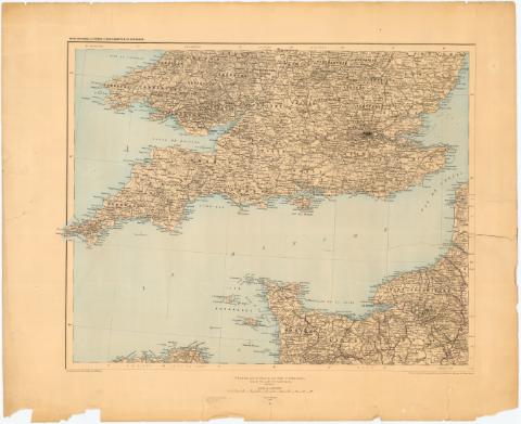
Title: France en 6 fenilles / par F. Prudent ; Dessiné le trait et la lettre par Weinreb ; Gravé le trait et la topographie par E. Delaune, la lettre par Er. Dumas - Vorzet
Material or type of resouce Area: Escala 1:1.000.000 ; [proye. conica]
Publication: [Paris] : Publiée par la Librairie Hachette & Cie., 1888
Physical description: 1 mapa en 6 h. : col. ; h. de 43x53,7 cm
Notes: Comprende el noreste de Francia, Belgica, Holanda, Luxemburgo y parte de Alemania
Coordenadas referidas al meridiano de Paris. Red geográfica de 1° en 1°
Relieve representado por normales
Indica los limites administrativos en rojo, verde y ocre
Incompleto, sólo se dispone de la hoja II y I
FRN
Materia / lugar / evento: Mapas generales
Divisiones administrativas
1888
Bélgica
Países Bajos
Luxemburgo
Alemania
Francia
Other authors: Prudent, F (Ferdinand), 1835-1915
Dumas-Vorzet, Edmond, 1841-1885
Delaune, E
Weinreb
Hachette (Firma)
UDC: 912(44-2/-5+492/493+435.9+430-15)'1888'
(492/493)
( 435.9)
(430-15)
Type of publication:
 Maps
Maps
Rights:
Préstamo:
 Disponible
