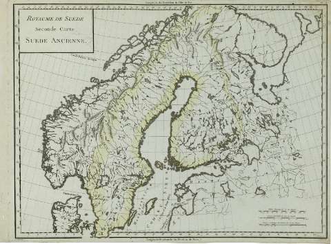
Royaume de Suede : seconde Carte Suede Ancienne


 Disponible Holdings
 Section: Maps, plans and nautical charts
Uniform title: Europa. O. Geografía histórica. 1797. 1:5208328 (0400)
Title: Royaume de Suede : seconde Carte Suede Ancienne / P.F. Tardieu sculp. ; André scrip.
Material or type of resouce Area: Escala [ca. 1:5.208.328]. 75 lieves communes de France, de 25 au Degré [= 6,4 cm]
Publication: Paris : Chez Mr. Mentelle ..., Rue de Seine Fauxbourg S. Germain ..., [1797 ?]
Physical description: 1 mapa : col. ; 34x49 cm
Content type: Imagen cartográfica
Media type: computadora
Carrier type: recurso en línea
Notes: Escala gráfica además en 'Milles Romain, de 75 au Degré', etc. Coordenadas : E1 -E42 /N70 -N55 . Meridiano de Paris. Coordenadas también del meridiano de Ferro
Márgenes graduados. - Dibujados meridianos y paralelos formando una cuadrícula. - Relieve representado por montes de perfil y sombreado. - Red hidrográfica destacada. - Frontera de Suecia delimitada por línea de color. - Costas sombreadas con un fino rayado
Copia digital. España : Ministerio de Cultura. Dirección General del Libro, Archivos y Bibliotecas, 2010
Other titles: En: Atlas nouveau. - Paris : Chez Mr. Mentelle Historiographe de Monseigneur le Comte d'Antois, Rue de Seine Fauxbourg S. Germain, Hotel de Mayence, [1797 ?]
Materia / lugar / evento: Geografía histórica
Mapas generales
Fronteras
Topónimos antiguos
Suecia
Finlandia
Other authors: André, Gaspard, fl. 1768-1801
Tardieu, Antoine-François, 1757-1822
Mentelle, Edmé, 1730-1815
UDC: 912:341.222(480+485)'400'
480
485
Type of publication:
 Maps
Maps
Rights:
Préstamo:
Disponible
