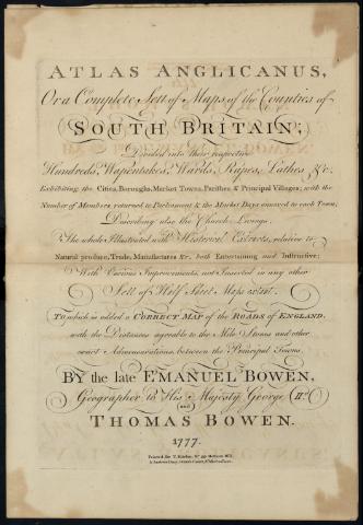
Atlas Anglicanus, Or a Complete Sett of Maps the...
Section: Maps, plans and nautical charts
Uniform title: Reino Unido. Mapas generales. Varias escalas (1777)
Title: Atlas Anglicanus, Or a Complete Sett of Maps the Countries of South Britain : Divided into their respective Hundreds, Wapentakes, Wards, Rapes, Lathes &c. / By the Emanuel Bowen and Thomas Bowen
Material or type of resouce Area: Varias escalas
Publication: [Londres] : Printed for T. Kitchin,Nº 59, Holborn Hill. & Andrew Dury, Duke's Court, St. Martins Lane, 1777
Physical description: 1 atlas : 45 lám. ; 27 x 23 cm
Media type: sin mediación
Notes: Relieve representado por símbolos
Señala vegetación
Contains: Lám. 1-2. England and Wales - lám. 3. Bedford Shire - lám. 4. Berk Shire - lám. 5. Buckingham-Shire - lám. 6. Cambridge Shire - lám. 7. Che-Shire - lám. 8. Cornwale - lám. 9. Derby Shire - lám. 10. Devon Shire - lám. 11. Dorset Shire - lám. 12. Durham - lám. 13. Essex - lám. 14. Gloucester Shire - lám. 15. Monmouth Shire - lám. 16. Hamp Shire - lám. 17. Hartford Shire - lám. 18. Hereford Shire - lám. 19. Huntingdon Shire - lám. 20. Kent - lám. 21. Lanca Shire - lám. 22. Leicester and Rutland - lám. 23. Lincoln Shire - lám. 24. Middle Sex - lám. 25. Norfolk - lám. 26. Northampton - lám. 27. Northumberland - lám. 28. Nottingham Shire - lám. 29. Oxford Shire - lám. 30. Shorp Shire - lám. 31. Somerset Shire - lám. 32. Stafford-Shire - lám. 33. Suffolk - lám. 34. Surrey - lám. 35. Sussex - lám. 36. Warwick Shire - lám. 37. Cumberland and Westmorland - lám. 38. Wilt Shire - lám. 39. Worcestér Shire - lám. 40. York Shire - lám. 41. The East Riding of York Shire - lám. 42. The North Riding of York Shire - lám. 43. The West Riding of York Shire - lám. 44. North Wales - lám. 45. South Wales
Materia / lugar / evento: Mapas generales
Gran Bretaña
Other authors: Bowen, Emanuel, m. 1767
Bowen, Thomas
UDC: 410
Type of publication:
![]() Maps
Maps
Préstamo:
![]() Disponible
Disponible


