Plan of the Anchorage at Savanna la Mer, Jamaica & the...


 Maps, plans and nautical charts
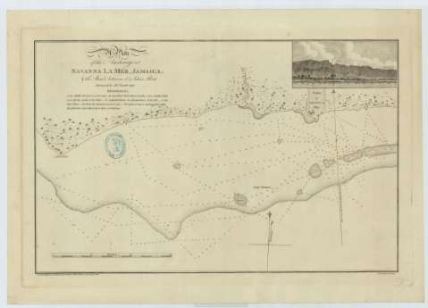
Plan of the Anchorage at Savanna la Mer, Jamaica & the Shoals between it & John's Point (Nove. 19 th. 1792)
Maps, plans and nautical charts
Plan of the Anchorage at Savanna la Mer, Jamaica & the Shoals between it & John's Point (Nove. 19 th. 1792)
 Disponible Holdings
 Section: Maps, plans and nautical charts
Title: Plan of the Anchorage at Savanna la Mer, Jamaica & the Shoals between it & John's Point / Surveyed by Jno. Leard, 1791 ; Neele, sculpt.
Material or type of resouce Area: Escala [ca. 1:38580], 3 miles [english nautic] [= 14,4 cm]
Publication: London : Publish by Jno. Leard & sold by Mount & Davidson, Tow er Hill, Nove. 19 th. 1792
Physical description: 1 carta náutica : Papel verjurado con marca de aguas: "VI" con escudo ; 41 x 58 cm
Content type: Imagen cartográfica
Media type: computadora
Carrier type: recurso en línea
Notes: Orientado con lis en la que se señala ademas la variación magnética observada
Relieve de perfil. Sondas batimétricas
Relación de los principales puntos del plano, indicados por clave alfabética
Inserta una perspectiva de costa. 7 x 14 cm
Sello del depósito general topográfico de ingenieros
Materia / lugar / evento: Cartas náuticas
Perspectivas de costas
Bahías
1791
1792
Other authors: Neele, Samuel John, 1758-1824
Leard, John
Mount & Davidson (Londres)
UDC: 729.2 Savanna La Mar
Type of publication:
Maps
Rights:
Préstamo:
Disponible
