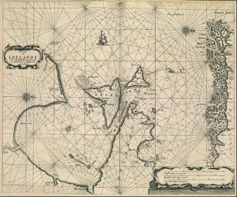
Pascaarte van Liiflandt ende Oost-Finlandt, van der Winda...


 Maps, plans and nautical charts
Pascaarte van Liiflandt ende Oost-Finlandt, van der Winda tot aende hoeck van Alandt ende voort tot Revel (1669)
Maps, plans and nautical charts
Pascaarte van Liiflandt ende Oost-Finlandt, van der Winda tot aende hoeck van Alandt ende voort tot Revel (1669)
 Disponible Holdings
 Section: Maps, plans and nautical charts
Uniform title: RIGA (Golfo). Cartas naúticas. 1669. Escala [ca. 1:820000]
Title: Pascaarte van Liiflandt ende Oost-Finlandt, van der Winda tot aende hoeck van Alandt ende voort tot Revel
Material or type of resouce Area: Escala [ca. 1:820000]
Publication, Production, Distribution, etc.: Producción: [Holanda], [1669]
Physical description: 1 carta náutica : grab. ; 43 x 53 cm
Content type: Imagen cartográfica
Media type: computadora
Carrier type: recurso en línea
Notes: Escalas gráficas de 20 millas inglesas y francesas de 20 al grado, 17 1/2 millas españolas de 17 1/2 al grado y 15 millas holandesas de 15 al grado [= 13,6 cm].
Orientado con lis en dos rosas de treinta y dos vientos
Relieve de perfil y sombreado
Carta de araña en la que se indican sondas, veriles, bancos de arena, fondeaderos y diques
Toponimia costera de los principales accidentes geográficos y núcleos de población
En el ángulo inferior derecho: "28"
Título y escalas gráficas enmarcados en sendas cartelas barrocas
Decorado con las figuras de un galeón y un monstruo marino
Copia digital. Madrid : Ministerio de Cultura, 2010
Other titles: En: Le Grand et Nouveau Miroir de la Mer. - [Amsterdam] : Pieter Goss, [1669]. - [Mapa 54]
UDC: 912:551.46]474.3:26.04)(480:26.04)(47:26.04)"1669"
(474.3:26.04 Riga)
(480:26.04 Finlandia)
(480:26.04 URSS)
Type of publication:
Maps
Rights:
Préstamo:
 Disponible sólo para consulta en sala
