Iberische Halbinsel seit dem Anfange des XVIten....


 Maps, plans and nautical charts
Iberische Halbinsel seit dem Anfange des XVIten. Jahrhunderts (1871)
- Spruner, Karl von, 1803-1892
Maps, plans and nautical charts
Iberische Halbinsel seit dem Anfange des XVIten. Jahrhunderts (1871)
- Spruner, Karl von, 1803-1892
 Disponible Holdings
 Section: Maps, plans and nautical charts
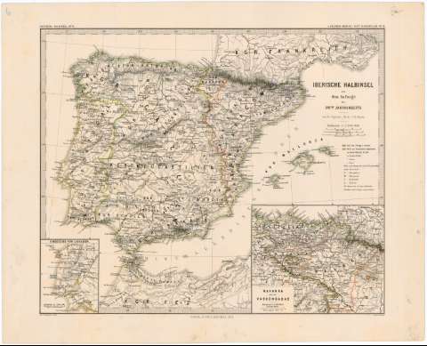
Title: Iberische Halbinsel seit dem Anfange des XVIten. Jahrhunderts / von K. v.Spruner ; revis. v. Th. Menke ; Gez. v. Hassenstein & Mayr.
Author: Spruner, Karl von, 1803-1892
[Iberische Halbinsel seit dem Anfange des XVIten. Jahrhunderts] All editions
Characteristics of the edition: 1871. 1:3.700.000. Alemán
Material or type of resouce Area: Escala 1:3.700.000
Publication: Gotha : Justus Perthes, 1871
Physical description: 1 mapa : graba, col. ; 33,3 x 40 cm
Content type: Imagen cartográfica
Media type: computadora
Carrier type: recurso en línea
Notes: Presenta los distintos reinos de la península Ibérica en el S. XVI
Escala expresada también en 15 millas geográficas de 15 al grado, 25 leguas españolas de 20 al grado y 25 leguas portuguesas de 18 al grado. Coordenadas referidas al meridiano de Hierro (E 6°50'--E 25°10'/N 44°20'--N 34°00'). Red geográfica de 2° en 2°
Relieve representado por normales
Límites de los reinos diferenciados por color
Tabla de signos convencionales para indicar núcleos de población de distinta categoría, clave cromática diferenciando distintos momentos históricos y clave alfabética para señalar ducados, marquesados, condados y baronías
Presenta los distintos reinos de la península Ibérica en el S. XVI
En el margen superior izquierdo: "Iberische Halbinsel N° VI" y en el superior derecho: "v. Sruner-Menke : Hist. Handatlas. N° 19"
Inserta: "Umgegend von Lissabon". Escala 1:1.500.000. 8,7 x 7 cm ; "Navarra und die Vascongadas". Escala 1:1.500.000. 12,5 x 15,5 cm
Materia / lugar / evento: Divisiones administrativas
Historia
España
Portugal
Navarra (Comunidad Autónoma)
País Vasco
Genre / form: Mapas generales
Other authors: Menke, Theodor, 1819-1892
Hassenstein, Bruno, 1839-1902
Mayr
Justus Perthes (Firma)
UDC: 912:(1-2/-5)(460)(469)"15"
(460)
(469)
(465)
(466)
Type of publication:
Maps
Rights:
Préstamo:
Disponible
