Iberische Halbinsel zur Ziet des Reichs der Westgothen...


 Maps, plans and nautical charts
Iberische Halbinsel zur Ziet des Reichs der Westgothen 531-711 n. Ch. (1871)
- Menke, Theodor, 1819-1892
Maps, plans and nautical charts
Iberische Halbinsel zur Ziet des Reichs der Westgothen 531-711 n. Ch. (1871)
- Menke, Theodor, 1819-1892
 Disponible Holdings
 Section: Maps, plans and nautical charts
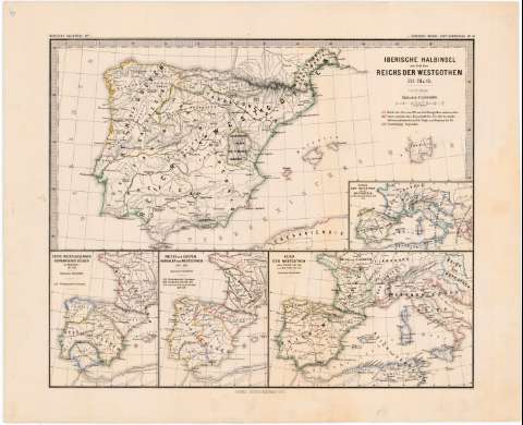
Title: Iberische Halbinsel zur Ziet des Reichs der Westgothen 531-711 n. Ch. / Von Th, Menke
Author: Menke, Theodor, 1819-1892
[Iberische Halbinsel zur zeit des Reichs der Westgothen 531-711 n. Ch] All editions
Characteristics of the edition: 1871. 1:5.000.000. Alemán
Material or type of resouce Area: aEscala 1:5.000.000
Publication: Gotha : Justus Perthes, 1871
Physical description: 1 mapa : grab., col ; 20 x 40 cm en h. de 40 x 49 cm
Content type: Imagen cartográfica
Media type: computadora
Carrier type: recurso en línea
Notes: Escala expresada también en 30 millas geográficas [= 4,4 cm]. Coordenadas referidas al meridiano de Hierro (E 5°40'--E 28°55'/N 44°00'--N 35°40'). Red geográfica de 1° en 1°
Relieve representado por normales
Límites de los reinos diferenciados por líneas de color
En el margen superior izquierdo: "Iberische Halbinsel N° 1" y en el superior derecho: "v. Spruner-Menke: Hist. Handatlas N° 14"
Incluye "Erste Niederlassungen Germanischer Vöcker in Hispaniae 411-420". 1:12.500.000. 13 x 10,3 cm ; "Reiche der Sueven Vandalen und Westgothen 420-460". 1:1250000. 13 x 10,3 cm ; "Reich der Westgothen unter Eurich (468-488) und Alarich II (488-507)". Escala 1:12.500.000. 13 x 19,5 cm
Inserta: "Reiche der Ostgothen und der Westgothen zu Theoderich d. Grn. Zeit + 526". 11,8 x 6,7 cm
Materia / lugar / evento: Germanos
Movimientos migratorios
Divisiones administrativas
España
Portugal
Europa del Sur
Genre / form: Mapas generales
Other authors: Spruner, Karl von, 1803-1892
UDC: 912:314.74+(1.2/.5)(4-14)"411/711"
(460)
(469)
(4-14)
Type of publication:
Maps
Rights:
Préstamo:
Disponible
