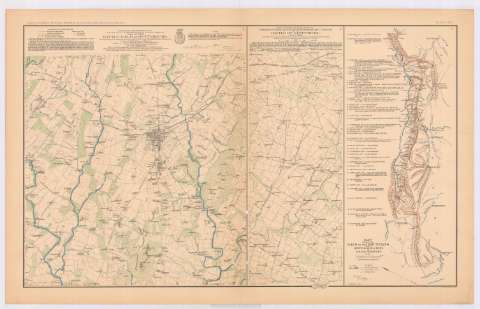
Map of the battle-field of Gettysburg


Section: Maps, plans and nautical charts
Title: Map of the battle-field of Gettysburg / surveyed and drawn under the direction of Bvt Maj. Gen. G.K. Warren, Maj. of Engineers, by 1st. Lieut. W.H. Chase, Corps of Engineers; assisted by 1st. Lieut. Thomas Turtle, Corps of Engineer, 2d. Lieut. F.A. Hinman, Corps of Engineer ; and civil assistant Capt. C.E. Davis... [et al.] ; draughtsmen Edwin A. Chase... [et al.]
Material or type of resouce Area: Escala [ca. 1:23461], 3000 feet [= 3,9 cm]
Publication: Washington : Government Printing Office, [189-?] (N.Y. [Nueva York] : Julius Bien & co.)
Physical description: 1 mapa : col. ; 42x36 cm, en h. de 47x75 cm
Content type: Imagen cartográfica
Media type: computadora
Carrier type: recurso en línea
Notes: En : Atlas to accompany the official records of the Union and Confederate armies 1861-1865. Plate XCV, n 1
Relieve : curvas de nivel
Orientado con flecha
Leyenda de signos utilizados
Figura nota explicativa de la construcción del mapa
Figura nota caligrafiada impresa del autor
En : Atlas to accompany the official records of the Union and Confederate armies 1861-1865
Materia / lugar / evento: Guerra civil
Batallas
Mapas militares
Planos de población
1863
Estados Unidos
Other authors: Chase, W. H Lieutenant
Turtle, Thomas
Hinman, F.A 2 Lieutenant Corps Engineers
Davis, C.E Captain
Warren, Gouverneur Kemble, 1830-1882
UDC: 912:355.4]:355.422(748 Gettysburg)'1863'
912:355(748 Gettysburg)'1863'
912:314(748 Gettysburg)(084.3)
748 Gettysburg
Type of publication:
 Maps
Maps
Rights:
Préstamo:
 Disponible
