West-Indian und Central-Amerika


Section: Maps, plans and nautical charts
Uniform title: AMERICA CENTRAL. Mapas generales. 1897. Escalas dif (1889-1897)
Title: West-Indian und Central-Amerika / gezeichnet von Herman Berghaus
Material or type of resouce Area: Escalas dif.
Publication: Gotha : Justus Perthes, [1897]
Physical description: 1 mapa en 1 hoja : col.34 x 56 o menor, en hoja de 50 x 59 cm
Content type: Imagen cartográfica
Media type: computadora
Carrier type: recurso en línea
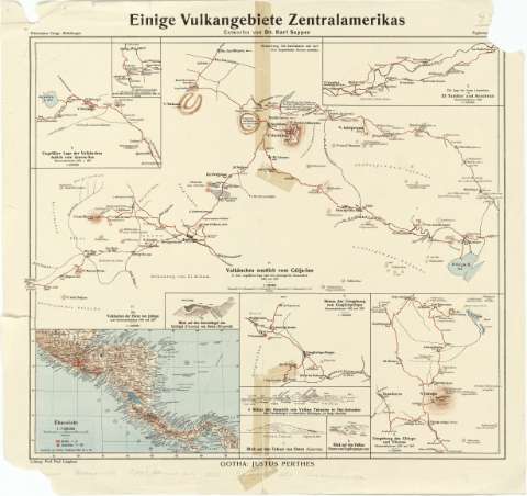
Notes: Comprende : "Vulkäuchen westlich vom Güija-See in ihrer ungefähren Lage nach den un korrigierten itinerarien 1895 und 1897". Escala 1:100000. "Vulkänchen der Ebene von Jutiapa nach itineraraufnahmen 1892 un 1897". Escala 1:100000. "Die Lage der freien Lavastroms von el Tambor und Antobran Itineraraufnahm en 1889". Escala 1:100000. "Die Lage des freien Lavastroms von El Florido (Guatemala) Itineraraufnahmen 1889 u. 92". Escala 1:100000. "Ungeder Vulkänchen östlich vom Ayarza-See Itineraraufnahmen 1892 u. 1897". Escala 1:100000. "Umgebung des Chingo und Viboras Itineraraufnahmen 1892 und1897". Escala 1:100000. "Skizze der Umgebung von Cuajiniquilapa Itineraraufnahmen 1892 und 1897". Escala 1:100000. "Blick auf den Vnkan Flores von Yupiltepeque aus". Sin escala. "Blick auf den Tahual von osten (Quevitas)".Sin escala. "Skizze der Aussicht von Vulkan Taburete in Ost-Salvador". Sinescala. "Blick auf deu Zentralkegel des Chiriqui (Panamá) vou Osten (Ringwall). Sin escala. "übersicht". Escala 1:7500000
Fecha de edición deducida a partir de los datos del mapa
Relieve por normales, sombreado y puntos acotados
En el ángulo superior derecho aparece el nombre de la sociedad creada porAugustus Herman Petermanns: "Petermanns Geogr. Mitteilungen"
Materia / lugar / evento: Mapas generales
Volcanes
Other authors: Sapper, Karl
Laughans, Paul
Perthes, Justus, 1749-1816
UDC: 912:551.21(728)"1897"
728
Type of publication:
 Maps
Maps
Rights:
Préstamo:
 Disponible
