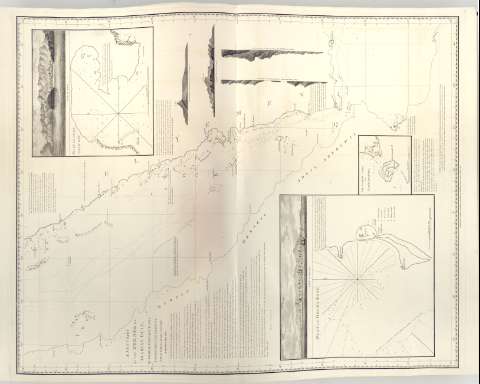
A New Chart of The Red Sea or Arabiau Golf


 Disponible Holdings
 Section: Maps, plans and nautical charts
Uniform title: MAR ROJO. Cartas náuticas. 1:1400000 (1804)
Title: A New Chart of The Red Sea or Arabiau Golf / by sir Home Popham K.M.F.R.S. Commanding His Majestys Naval Forces on That Station
Material or type of resouce Area: Escala [Ca. 1:1.400.000]
Publication: [London ?] : Published by W. Faden Geographer to The King & to H.R.H. The Principe of Wales, 1804
Physical description: 1 carta nautica ; 62x76 cm en h. de 85x88 cm, pleg en 49x65 cm
Content type: Imagen cartográfica
Media type: computadora
Carrier type: recurso en línea
Notes: Presenta además un Plano de 'Mocha Road', 'The Narrow Strait or Babelmaudel', 'Plan of Aden Back Bay' y 4 perfiles
En : 'Charts Red Sea'
Escala grafica hallada a partir de un grado de latitud [= 7'5 cm]. Coordenadas referidas al meridiano de Hierro (E37°30'-E45°30'/N20°0'-N10°0').
Relieve representado por sondas batimetricas
Indica veriles, bajos y fondeaderos
Nota sobre Sir Home Popham y su estancia en el mar Rojo
En : Charts Red Sea
Other authors: Popham, Sir Home Riggs
Faden, William, 1749-1836
UDC: 912:[551.46:528.9](267.33)'1804'
267.33
Type of publication:
 Maps
Maps
Rights:
Préstamo:
Disponible
