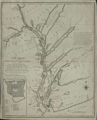
Map of the Great River St. John & Waters : (The first...


 Maps, plans and nautical charts
Map of the Great River St. John & Waters : (The first ever published) from the Bay of Fundy, up to St. Anns or... (1788)
Maps, plans and nautical charts
Map of the Great River St. John & Waters : (The first ever published) from the Bay of Fundy, up to St. Anns or... (1788)
 Disponible Holdings
 Section: Maps, plans and nautical charts
Title: Map of the Great River St. John & Waters : (The first ever published) from the Bay of Fundy, up to St. Anns or Frederick's town... / by Robert Campbell, surveyor, Capt. of the 40 Company of St. John Loyalist
Material or type of resouce Area: Escala [ca. 1:250.000] ( (O 66°45'-O 64°52'/N 46°30'-N 44°46'), 10 miles [= 6,5cm])
Publication: London : Robert Campbell, 1788
Physical description: 1 mapa ; 51 x 42 cm
Content type: Imagen cartográfica
Media type: computadora
Carrier type: recurso en línea
Notes: Comprende el curso del río Saint John así como las cuencas de los principales lagos
Presenta además un plano de la ciudad de St. John
Coordenadas referidas al meridiano de Londres (O 66º45'-O 64º52'/N 46º30'-N 44º46'). Orientado con lis en rosa de 8 vientos
Figuran sombreadas las orillas de los principales lagos
Indica los principales núcleos urbanos y condados a los que pertenecen
Nota explicativa con información sobre la profundidad, corrientes, navegabilidad del río
Materia / lugar / evento: Cuencas hidrográficas
Saint Johns
Other authors: Campbell, Robert
UDC: 715:282.27
Type of publication:
Maps
Rights:
Préstamo:
Disponible
