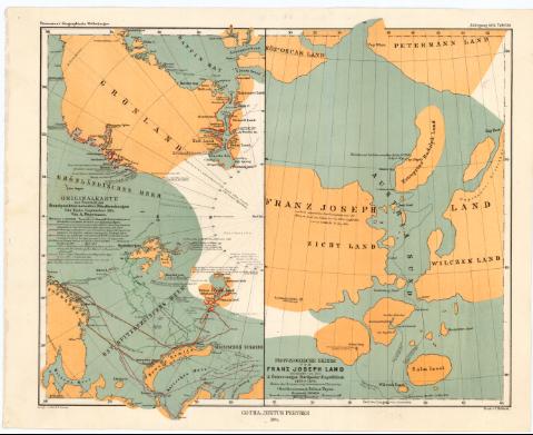
Original karte zur Ubersicht des Standpunktes neuester...
Section: Maps, plans and nautical charts
Title: Original karte zur Ubersicht des Standpunktes neuester Polarforschungen bis Ende September 1874 / Von A. Petermann ; Autogr. v. Peip. & B. Domann
Material or type of resouce Area: Escala 16000000 (O 85°-E 85°/N 90°-N 55°)
Publication: Gotha : Justus Perthes, 1874 (Gotha : Druck v. C. Hellfarth)
Physical description: 1 mapa : col. ; 25,8 x 14,8 cm en h. de 27,7 x 34,6 cm
Notes: En: 'Petermann's Geographische Mittheilungen. Jahrgang 1874. Tafel 20'
Escala gráfica de 100 millas náuticas [= 1,2 cm]. Red geográfica de 10° en 10°
Tabla de signos convencionales para indicar las diferentes expediciones en la zona polar
En: 'Petermann's Geographische Mittheilungen. Jahrgang 1874. Tafel 20'
Provisorische Skizze von Franz Joseph Land entdeckt von der 2 Osterr-ungar Nordpolar-Expedition 1873 & 1874
Other authors: Petermann, Augustus Herman
Domann, B
Peip, C
Perthes, Justus, 1749-1816
Hellfarth, C
UDC: 912:656.02(98)'1616/1874'
(988)
Type of publication:
![]() Maps
Maps
Préstamo:
![]() Disponible
Disponible


