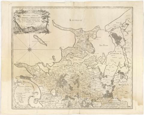
Den Nord Vestlige Fierdedeel af Siaelland


 Disponible Holdings
 Section: Maps, plans and nautical charts
Uniform title: SELANDIA (Dinamarca) (Isla). Mapas generales. 1:120000 (1771)
Title: Den Nord Vestlige Fierdedeel af Siaelland / under det Kongl : Viidenskabernes Societets Direction ved rigtig Landmaaling optaget og ved trigonometriske famt astronomiske Operationes provet, tegnet af C. Wessel : Gravée a L'Eau forte par Martin, et terminée au Burin par Guiter
Material or type of resouce Area: Escala [ca. 1:120000] 2 Geographiske Mul [= 12 cm]
Publication: [Kobenhavn ?(Copenhague) : Kongl. Viideskabernes Societes Direction], 1771
Physical description: 1 mapa ; 56,3x66 cm en h. de 64x78 cm
Notes: Escalas gráficas de 2 Almindelige Danske [= 12 cm], 2400 Alen [= 12 cm]. Coordenadas referidas al meridiano de Copenhague (O1#42'-O0#28'/N56#5'-55#29'). Recuadro geográfico de 5' en 5'. Orientado con lis en rosa de 16 vientos prolongados
Relieve representado por normales
Tabla de signos convencionales para indicar núcleos de población de distinta categoria, molinos, caminos y limites administrativos
Indica masas forestales
Título enmarcado en paisaje rural
Sello en seco del Depósito de la Guerra
Materia / lugar / evento: Mapas generales
1771
Selandia (Isla)
Frederiksborg
Selandia Occidental
Other authors: Wessel, Caspar, 1745-1818
Martin
Guiter, Ch. A
UDC: 912(489-17 Selandia, isla)'1771'
(489-328 Frederiksborg)
(489-328 Vestseelland)
Type of publication:
 Maps
Maps
Rights:
Préstamo:
Disponible
